Home
Weather Maps
Tables
Forum
Community
Service
Shop
My AWEKAS
AWEKAS Home
AWEKAS Mobile Home
Data protection
Imprint
Weather overview
Temperature
Air Pressure
Wind
Precipitation
Snow
Webcam
Sun
Dew point
Humidity
Current weather data
Current weather situation
Current weather warnings
Forum overview
News
Help and instructions
Wishes and suggestions
Register new
Memberlist
Member Map
Donations to AWEKAS
Banner and logo
Weather widget
AWEKAS shop
My station panel
Instrument designer
Stationsweb
Change user data
Report your weather
Data import/export
AWEKAS Benutzer:
login
Nearest stations
Information for station Thyrnau
Aschenberg
Brunnenthal-Kreuzb.
Bubing
Büchlberg
Edt
Fürstenzell DWD
Kopfing - Mitteredt
Krennbauer Grub
Nebelberg
Neukirchen am Inn
Neureichenau
Obernzell-Haar
Passau-Hacklberg
Passau-Rittsteig
Ringlholz
Ruderting
Schaerding
Schärding I
St. Roman
Thyrnau-Kellberg
Tittling
Waldkn.-Oberleinbach
Wernstein am Inn
Wernstein--Öhret
Wernstein/Stöbichen
Station name
Thyrnau
Country
Germany
Height above sea level
453 m
Geographical position
13° 33' 54.77'' East / 48° 36' 48.88'' North
Data transfer
Bresser Fastlink
Last updated
12/16/2022 12:37 pm
AWEKAS Plus
YES
AWEKAS id
20817
Stations blog
edit
no station blog available
Information for station
Type of station
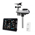
BRESSER Profi W-LAN Wetter Center 6in1
these sensors are in use
count
Temperature
ventilated radiation shield
1
Air Pressure
1
Precipitation
1
Anemometer
mounting height: 26.25 ft
1
UV
1
Solar radiation
1
Soil temperature
1
To map
Compare values with adjacent stations
To instrument page of the station
Sponsoring
MEMBERS
17986 Members at this time
13195 stations online
New stations:
Clinton Bluff
Giardino
Lohmen 02
Sorgenlos
Waldhausen/Eder
Weather Report
Cuers
heavy cloud / 79.3°F -
Sibenik-Krvavice
clear / 80.1°F -
Current Warnings
no warnings at the moment
Minimum/ Maximum
Temperature
Olvey, AR
102.4°F -
Ensay
29.7°F -
Wind Speed
Poingam MF
29.3 mph - E -
Precipitation
Chivilcoy Bs As
3.9 in -
Visitors today: 6926
currently 48 visitors on AWEKAS
Display Settings
Language
German
English
Dutch
French
Italian
Spanish
Measurement Units
Metric system
American system