Home
Weather Maps
Tables
Forum
Community
Service
Shop
My AWEKAS
AWEKAS Home
AWEKAS Mobile Home
Data protection
Imprint
Weather overview
Temperature
Air Pressure
Wind
Precipitation
Snow
Webcam
Sun
Dew point
Humidity
Current weather data
Current weather situation
Current weather warnings
Forum overview
News
Help and instructions
Wishes and suggestions
Register new
Memberlist
Member Map
Donations to AWEKAS
Banner and logo
Weather widget
AWEKAS shop
My station panel
Instrument designer
Stationsweb
Change user data
Report your weather
Data import/export
AWEKAS Benutzer:
login
Nearest stations
Information for station Aschenberg
Andorf
Andorf-Humerleiten
Andorf/Kreilern
Brunnenthal-Kreuzb.
Bubing
Edenrad
Edt
Fürstenz.-Engertsham
Haula (Andorf)
Hörzingerwald
Kollerschlag
Kopfing - Mitteredt
Krennbauer Grub
Marsbach
Neukirchen am Inn
Neukirchen am Walde
Neukirchen-Buchberg
Obernzell-Haar
Passau-Hacklberg
Passau-Innstadt
Peuerbach/Höhenstein
Ringlholz
Schaerding
Schärding
Schärding I
Sigharting-Wurmsdobl
St. Roman
St.Willibald
Thyrnau-Kellberg
Wernstein am Inn
Wernstein--Öhret
Wernstein/Stöbichen
Station name
Aschenberg
Country
Austria
Height above sea level
650 m
Geographical position
13° 37' 48.35'' East / 48° 29' 25.51'' North
Data transfer
Bresser Fastlink
Last updated
18.2.2026 16:30
AWEKAS Plus
YES
AWEKAS id
40216
Stations blog
edit
no station blog available
Information for station
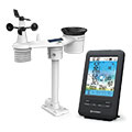
Type of station
BRESSER 4-Tage 4CAST 7003200
these sensors are in use
count
Temperature
ventilated radiation shield
1
Air Pressure
1
Precipitation
1
Anemometer
mounting height: 5 m
1
UV
1
Solar radiation
1
Soil temperature
1
Soil moisture
1
Leaf wetness
1
To map
Compare values with adjacent stations
To instrument page of the station
Sponsoring
MEMBERS
20035 Members at this time
13507 stations online
New stations:
Cadarga
Lingen Biene II
Agios Adrianos
Beilrode
Gistel
Weather Report
Albertville
heavy cloud / 9.4°C -
Brooksville, FL
clear / 20.1°C -
Current Warnings
no warnings at the moment
Minimum/ Maximum
Temperature
Mbodiène, La Gazelle
34.7°C -
Royal Oak(Calgary)
-27.6°C -
Wind Speed
Chasseral MCH
79.2km/h - SW -
Precipitation
Poindimie MF
69.8 l/m² -
Visitors today: 4637
currently 38 visitors on AWEKAS
Display Settings
Language
German
English
Dutch
French
Italian
Spanish
Measurement Units
Metric system
American system