Home
Weather Maps
Tables
Forum
Community
Service
Shop
My AWEKAS
AWEKAS Home
AWEKAS Mobile Home
Data protection
Imprint
Weather overview
Temperature
Air Pressure
Wind
Precipitation
Snow
Webcam
Sun
Dew point
Humidity
Current weather data
Current weather situation
Current weather warnings
Forum overview
News
Help and instructions
Wishes and suggestions
Register new
Memberlist
Member Map
Donations to AWEKAS
Banner and logo
Weather widget
AWEKAS shop
My station panel
Instrument designer
Stationsweb
Change user data
Report your weather
Data import/export
AWEKAS Benutzer:
login
Nearest stations
Information for station Haula (Andorf)
Andorf
Andorf-Humerleiten
Andorf/Kreilern
Aschenberg
Aspeth
Aurolzm. Schöndorf
Aurolzmuenster
Brunnenthal-Kreuzb.
Bubing
Edenrad
Edt
Forchtenau
Fuchshub (OÖ)
Gögging
Haag am Hausruck
Kallham-Mairhof
Kopfing - Mitteredt
Marsbach
Michaelnbach
Neukirchen am Walde
Neukirchen-Buchberg
Ort im Innkreis
Peuerbach/Höhenstein
Pram
Pram (Rühring)
Reichersberg
Ried Im Innkreis
Riedau
Ringlholz
Schaerding
Schärding
Schärding I
Schatzdorf
Sigharting-Wurmsdobl
St. Roman
St.Willibald
Tullern (St. Aegidi)
Utzenaich
Waizenkirchen Geosp.
Waizenkirchen Süd
Wernstein am Inn
Wernstein--Öhret
Wernstein/Stöbichen
Station name
Haula (Andorf)
Country
Austria
Height above sea level
409 m
Geographical position
13° 36' 15.67'' East / 48° 22' 19.83'' North
Data transfer
Bresser Fastlink
Last updated
19.6.2025 11:41
AWEKAS Plus
YES
AWEKAS id
38917
Stations blog
edit
no station blog available
Information for station
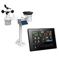
Type of station
BRESSER 11-Tage 4CAST (7003240)
these sensors are in use
count
Temperature
1
Air Pressure
1
Precipitation
1
Anemometer
mounting height: 409 m
1
UV
1
Solar radiation
1
To map
Compare values with adjacent stations
To instrument page of the station
Sponsoring
MEMBERS
14871 Members at this time
10309 stations online
New stations:
Zerbst Airport EDUZ
Tochheim
Eudenbach-City
Giragello
Plech-Nord
Weather Report
Villenauxe-la-Grande
sunny sky -
Peillac
clear / 27.5°C -
Current Warnings
Janczewo
squalls
Minimum/ Maximum
Temperature
Vélez-Málaga
38.3°C -
Aconquija (CTC)
-2°C -
Wind Speed
Kintai
38.5km/h - W -
Precipitation
Heath Ky
47.6 l/m² -
Visitors today: 2512
currently 52 visitors on AWEKAS
Display Settings
Language
German
English
Dutch
French
Italian
Spanish
Measurement Units
Metric system
American system