Home
Weather Maps
Tables
Forum
Community
Service
Shop
My AWEKAS
AWEKAS Home
AWEKAS Mobile Home
Data protection
Imprint
Weather overview
Temperature
Air Pressure
Wind
Precipitation
Snow
Webcam
Sun
Dew point
Humidity
Current weather data
Current weather situation
Current weather warnings
Forum overview
News
Help and instructions
Wishes and suggestions
Register new
Memberlist
Member Map
Donations to AWEKAS
Banner and logo
Weather widget
AWEKAS shop
My station panel
Instrument designer
Stationsweb
Change user data
Report your weather
Data import/export
AWEKAS Benutzer:
login
Nearest stations
Information for station Taufkirchen (Vils)
Bockhorn-Oberstrogn
Dorfen
Geisenhsn.Holzhausen
Hohenpolding
HohenpoldingStarzell
Isen/Obb.
Kumhausen-Preisenbg.
Landshut
Moosburg/Isar
Neuhausen, Erding
Oberdorfen
St. Wolfgang (Obb.)
St.Wolfgang
St.Wolfgang-Armstorf
Stefanskirchen
Vilsheim
Wörth-Hörlkofen
Station name
Taufkirchen (Vils)
Country
Germany
Height above sea level
487 m
Geographical position
12° 6' 43.64'' East / 48° 20' 51.67'' North
Data transfer
WU Fastlink
Last updated
7.9.2025 19:08
AWEKAS Plus
YES
AWEKAS id
35725
Stations blog
edit
no station blog available
Information for station
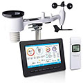
Type of station
Ecowitt HP255x
these sensors are in use
count
Temperature
1
Air Pressure
1
Precipitation
1
Anemometer
mounting height: 11 m
1
UV
1
Solar radiation
1
Soil temperature
4
Soil moisture
4
Link to station website Taufkirchen (Vils)
To map
Compare values with adjacent stations
To instrument page of the station
Sponsoring
MEMBERS
18079 Members at this time
13219 stations online
New stations:
Windelsbach-Hornau
Po?aniec III
Wien, Schottenbastei
Halblech
Hemmet, Nørre Bork
Weather Report
Reichmannsdorf
partly cloudy / 15.8°C -
Sibenik-Krvavice
clear / 24.7°C -
Current Warnings
no warnings at the moment
Minimum/ Maximum
Temperature
Mossul
35.8°C -
Kawerau
-0.1°C -
Wind Speed
Paiblesgarry/N.Uist
57.5km/h - S -
Precipitation
South Windsor
87.9 l/m² -
Visitors today: 4813
currently 30 visitors on AWEKAS
Display Settings
Language
German
English
Dutch
French
Italian
Spanish
Measurement Units
Metric system
American system