Home
Weather Maps
Tables
Forum
Community
Service
Shop
My AWEKAS
AWEKAS Home
AWEKAS Mobile Home
Data protection
Imprint
Weather overview
Temperature
Air Pressure
Wind
Precipitation
Snow
Webcam
Sun
Dew point
Humidity
Current weather data
Current weather situation
Current weather warnings
Forum overview
News
Help and instructions
Wishes and suggestions
Register new
Memberlist
Member Map
Donations to AWEKAS
Banner and logo
Weather widget
AWEKAS shop
My station panel
Instrument designer
Stationsweb
Change user data
Report your weather
Data import/export
AWEKAS Benutzer:
login
Nearest stations
Information for station Ahaus DWD
Ahaus Mitte-Nord
Ahaus Nord
Ahaus-Ottenstein
Ammeloe NRW
Coesfeld-Stockum
De Marke Losser
Enschede-Hogeland
Enschede-Laares
Enschede-Rigtersblek
Enschede-Roombeek
Enschede-Stadsveld
Glanerbrug Oost
Gronau-West
Gronau/W. (Nord)
Haaksbergen-Zuid
Legden
Overdinkel
Rosendahl
Rutbeek (Enschede)
Südlohn
Südlohn Nord
Twekkelerveld
Vreden-Doemern
Vreden-Lünten
Winterswijk
Station name
Ahaus DWD
Country
Germany
Height above sea level
46 m
Geographical position
6° 56' 27.24'' East / 52° 4' 52.68'' North
Data transfer
manuell
Last updated
11/3/2025 4:50 am
AWEKAS Plus
YES
AWEKAS id
44426
Stations blog
edit
no station blog available
Information for station
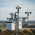
Type of station
DWD-Wetterstation
these sensors are in use
count
Temperature
1
Air Pressure
1
Precipitation
1
Anemometer
mounting height: 9.84 ft
1
UV
1
Solar radiation
1
Soil temperature
4
Link to station website Ahaus DWD
To map
Compare values with adjacent stations
To instrument page of the station
Sponsoring
MEMBERS
18306 Members at this time
13077 stations online
New stations:
Schwabach Süd
Sant Cugat
Fuerth
Taura-Köthensdorf 2
Langenwang
Weather Report
Vid
overcast sky / 62.8°F -
Himberg bei Wien
light rain / 48.9°F -
Current Warnings
no warnings at the moment
Minimum/ Maximum
Temperature
Singleton Heights
94.3°F -
Aiguille Du Midi MF
7.2°F -
Wind Speed
Cagnano MF
38 mph - W -
Precipitation
Cave (Latium)
1.6 in -
Visitors today: 594
currently 18 visitors on AWEKAS
Display Settings
Language
German
English
Dutch
French
Italian
Spanish
Measurement Units
Metric system
American system