Home
Weather Maps
Tables
Forum
Community
Service
Shop
My AWEKAS
AWEKAS Home
AWEKAS Mobile Home
Data protection
Imprint
Weather overview
Temperature
Air Pressure
Wind
Precipitation
Snow
Webcam
Sun
Dew point
Humidity
Current weather data
Current weather situation
Current weather warnings
Forum overview
News
Help and instructions
Wishes and suggestions
Register new
Memberlist
Member Map
Donations to AWEKAS
Banner and logo
Weather widget
AWEKAS shop
My station panel
Instrument designer
Stationsweb
Change user data
Report your weather
Data import/export
AWEKAS Benutzer:
login
Nearest stations
Information for station St.Veit im Pongau
Bad Hofgastein
Bischofshofen
Bischofshofen Sbg.
Großarl
Großarl Zentrum
Hüttschlag
Mühlbach a.Hochkönig
Rauris
Rauris Geosphere
Rauris-Mitte
Rauris-Wörth
St.Johann im Pongau
Tenneck Rainlehen
Station name
St.Veit im Pongau
Country
Austria
Height above sea level
749 m
Geographical position
13° 9' 18'' East / 47° 19' 45'' North
Data transfer
manuell
Last updated
26.9.2025 07:30
AWEKAS Plus
YES
AWEKAS id
43763
Stations blog
edit
no station blog available
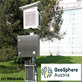
Information for station
Type of station
Geosphere Austria TAWES-Messstation
these sensors are in use
count
Temperature
1
Air Pressure
1
Precipitation
1
Anemometer
mounting height: 3 m
1
UV
1
Solar radiation
1
Soil temperature
4
Soil moisture
4
Link to station website St.Veit im Pongau
To map
Compare values with adjacent stations
To instrument page of the station
Sponsoring
MEMBERS
18172 Members at this time
13153 stations online
New stations:
karymshina
Ste-anne Marly MF
Grasse 4 chemins
Rheinfelden-Salmen
Berlin Lichterfelde
Weather Report
Hartberg / Kroisbach
rain / 12.1°C -
Albertville
cloudy / 10.4°C -
Current Warnings
no warnings at the moment
Minimum/ Maximum
Temperature
Copperwood, AZ
33.1°C -
Aiguille Du Midi MF
-9.3°C -
Wind Speed
Kionia - Tinos
52.5km/h - NE -
Precipitation
Burra NSW
118.6 l/m² -
Visitors today: 3039
currently 65 visitors on AWEKAS
Display Settings
Language
German
English
Dutch
French
Italian
Spanish
Measurement Units
Metric system
American system