Home
Weather Maps
Tables
Forum
Community
Service
Shop
My AWEKAS
AWEKAS Home
AWEKAS Mobile Home
Data protection
Imprint
Weather overview
Temperature
Air Pressure
Wind
Precipitation
Snow
Webcam
Sun
Dew point
Humidity
Current weather data
Current weather situation
Current weather warnings
Forum overview
News
Help and instructions
Wishes and suggestions
Register new
Memberlist
Member Map
Donations to AWEKAS
Banner and logo
Weather widget
AWEKAS shop
My station panel
Instrument designer
Stationsweb
Change user data
Report your weather
Data import/export
AWEKAS Benutzer:
login
Nearest stations
Information for station Rauris-Wörth
Anthering
Bad Gastein
Bad Hofgastein
Böckstein-Anlauftal
Bucheben
Bucheben (Berg)
Großarl
Großarl Zentrum
Kolm Saigurn GS
Rauris
Rauris Geosphere
Rauris-Mitte
Rauris/Hochberg
Sonnblick
St.Veit im Pongau
Zell am See
Station name
Rauris-Wörth
Country
Austria
Height above sea level
950 m
Geographical position
12° 58' 44.67'' East / 47° 11' 52.62'' North
Data transfer
Bresser Fastlink
Last updated
1/16/2026 6:09 am
AWEKAS Plus
YES
AWEKAS id
38077
Stations blog
edit
no station blog available
Information for station
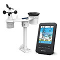
Type of station
BRESSER 4-Tage 4CAST 7003200
these sensors are in use
count
Temperature
1
Air Pressure
1
Precipitation
1
Anemometer
mounting height: 39.37 ft
1
UV
1
Solar radiation
1
To map
Compare values with adjacent stations
To instrument page of the station
Sponsoring
MEMBERS
19882 Members at this time
13419 stations online
New stations:
Ratingen Ost
Kingswood
Mileham
Hemer-Brockhausen
Rissing (Cham)
Weather Report
Askim
light snow sh. -
Hoesdorf
partly cloudy / 49.8°F -
Current Warnings
no warnings at the moment
Minimum/ Maximum
Temperature
Paita MF
101.3°F -
Ilyino
-24.3°F -
Wind Speed
Brocken DWD
49.9 mph - SW -
Precipitation
Afaahiti 3 MF
2.1 in -
Visitors today: 674
currently 14 visitors on AWEKAS
Display Settings
Language
German
English
Dutch
French
Italian
Spanish
Measurement Units
Metric system
American system