Home
Weather Maps
Tables
Forum
Community
Service
Shop
My AWEKAS
AWEKAS Home
AWEKAS Mobile Home
Data protection
Imprint
Weather overview
Temperature
Air Pressure
Wind
Precipitation
Snow
Webcam
Sun
Dew point
Humidity
Current weather data
Current weather situation
Current weather warnings
Forum overview
News
Help and instructions
Wishes and suggestions
Register new
Memberlist
Member Map
Donations to AWEKAS
Banner and logo
Weather widget
AWEKAS shop
My station panel
Instrument designer
Stationsweb
Change user data
Report your weather
Data import/export
AWEKAS Benutzer:
login
Nearest stations
Information for station Klagenfurt a. W. II
Ebenthal(Ktn)-Pfaff.
Feldkirchen Geospher
Feldkirchen(Kärnten)
Ferlach
Ferlach Geosphere
Göltschach
Grafenstein
Gramilach
Großkleinberg
Hanse
Klagenf-Schmelzhütte
Klagenfurt Flughafen
Klagenfurt Geosphere
Köttmannsdorf
Loibl/Tunnel
Magdalensberg
Magdalensberg-Erlach
Poertschach
Poggersdorf
Sinach
St.Veit/Glan
Tanzenberg
Treffen (Kärnten)
Untertoellern
Unterwaidisch
Velden am Wörthersee
Wurdach
Wurzen-Ebenfeld(Ktn)
Station name
Klagenfurt a. W. II
Country
Austria
Height above sea level
446 m
Geographical position
14° 16' 15.73'' East / 46° 36' 46.21'' North
Data transfer
Bresser Fastlink
Last updated
21.10.2025 20:47
AWEKAS Plus
YES
AWEKAS id
35197
Stations blog
edit
no station blog available
Information for station
Type of station
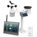
BRESSER MeteoChamp HD 7003510
these sensors are in use
count
Temperature
1
Air Pressure
1
Precipitation
1
Anemometer
mounting height: 2 m
1
UV
1
Solar radiation
1
To map
Compare values with adjacent stations
To instrument page of the station
Sponsoring
MEMBERS
18259 Members at this time
13224 stations online
New stations:
Abonos Cassani Baena
Nannup
Omoa MF
Digne-les-Bains
Walbersdorf
Weather Report
Sibenik-Krvavice
cloudy / 16.6°C -
Bristol, NH
partly cloudy / 17.3°C -
Current Warnings
no warnings at the moment
Minimum/ Maximum
Temperature
Córdoba, Plaza Pizzi
35.1°C -
Aiguille Du Midi MF
-5.3°C -
Wind Speed
Saint-clement Des MF
65.9km/h - SW -
Precipitation
Carrara
142 l/m² -
Visitors today: 6410
currently 34 visitors on AWEKAS
Display Settings
Language
German
English
Dutch
French
Italian
Spanish
Measurement Units
Metric system
American system