Home
Weather Maps
Tables
Forum
Community
Service
Shop
My AWEKAS
AWEKAS Home
AWEKAS Mobile Home
Data protection
Imprint
Weather overview
Temperature
Air Pressure
Wind
Precipitation
Snow
Webcam
Sun
Dew point
Humidity
Current weather data
Current weather situation
Current weather warnings
Forum overview
News
Help and instructions
Wishes and suggestions
Register new
Memberlist
Member Map
Donations to AWEKAS
Banner and logo
Weather widget
AWEKAS shop
My station panel
Instrument designer
Stationsweb
Change user data
Report your weather
Data import/export
AWEKAS Benutzer:
login
Nearest stations
Information for station Klagenfurt Flughafen
Ebenthal(Ktn)-Pfaff.
Feldkirchen Geospher
Feldkirchen(Kärnten)
Ferlach Geosphere
Göltschach
Grafenstein
Gramilach
Großkleinberg
Klagenf-Schmelzhütte
Klagenfurt a. W. II
Klagenfurt Geosphere
Köttmannsdorf
Magdalensberg
Magdalensberg-Erlach
Pirkach
Poertschach
Sinach
St.Veit/Glan
Tanzenberg
Untertoellern
Unterwaidisch
Wurdach
Station name
Klagenfurt Flughafen
Country
Austria
Height above sea level
450 m
Geographical position
14° 19' 6'' East / 46° 38' 54'' North
Data transfer
manuell
Last updated
13.2.2026 22:00
AWEKAS Plus
YES
AWEKAS id
43659
Stations blog
edit
no station blog available
Information for station
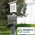
Type of station
Geosphere Austria TAWES-Messstation
these sensors are in use
count
Temperature
1
Air Pressure
1
Precipitation
1
Anemometer
mounting height: 3 m
1
UV
1
Solar radiation
1
Soil temperature
4
Soil moisture
4
Link to station website Klagenfurt Flughafen
To map
Compare values with adjacent stations
To instrument page of the station
Sponsoring
MEMBERS
20016 Members at this time
13510 stations online
New stations:
Krefeld-Fischeln
Kingston, TAS
Kleinpertenschlag 2
Friedberg (Stmk.)
Sernadas
Weather Report
Willow, AK
heavy cloud / -5.2°C -
Bourg-Saint-Bernard
heavy cloud / 8.7°C -
Current Warnings
no warnings at the moment
Minimum/ Maximum
Temperature
West End, Village
38.9°C -
Slagnäs, Gasa
-35.3°C -
Wind Speed
Patscherkofel
67km/h - S -
Precipitation
Gökova
108.4 l/m² -
Visitors today: 6851
currently 34 visitors on AWEKAS
Display Settings
Language
German
English
Dutch
French
Italian
Spanish
Measurement Units
Metric system
American system