Home
Weather Maps
Tables
Forum
Community
Service
Shop
My AWEKAS
AWEKAS Home
AWEKAS Mobile Home
Data protection
Imprint
Weather overview
Temperature
Air Pressure
Wind
Precipitation
Snow
Webcam
Sun
Dew point
Humidity
Current weather data
Current weather situation
Current weather warnings
Forum overview
News
Help and instructions
Wishes and suggestions
Register new
Memberlist
Member Map
Donations to AWEKAS
Banner and logo
Weather widget
AWEKAS shop
My station panel
Instrument designer
Stationsweb
Change user data
Report your weather
Data import/export
AWEKAS Benutzer:
login
Nearest stations
Information for station HohenpoldingStarzell
Altdorf b. Landshut
Altdorf/Ndb.
Bockhorn-Oberstrogn
Bodenkirchen Nord
Bruckberg
Bruckberg-Gündlkofen
Ergolding
Geisenhausen(Hofmü.)
Geisenhsn.Holzhausen
Hohenpolding
Kumhausen-Preisenbg.
Landshut
Landshut-Altstadt
Landshut-Peter Paul
Moosburg/Isar
St. Wolfgang (Obb.)
St.Wolfgang
St.Wolfgang-Armstorf
Taufkirchen (Vils)
Vilsbiburg
Vilsbiburg-Achldorf
Vilsheim
Station name
HohenpoldingStarzell
Country
Germany
Height above sea level
487 m
Geographical position
12° 8' 10.06'' East / 48° 23' 42.46'' North
Data transfer
Bresser Fastlink
Last updated
6/20/2025 4:22 am
AWEKAS Plus
YES
AWEKAS id
35091
Stations blog
edit
no station blog available
Information for station
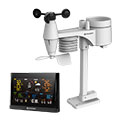
Type of station
BRESSER WLAN Comfort 7003300
these sensors are in use
count
Temperature
1
Air Pressure
1
Precipitation
1
Anemometer
mounting height: 6.56 ft
1
UV
1
Solar radiation
1
To map
Compare values with adjacent stations
To instrument page of the station
Sponsoring
MEMBERS
14874 Members at this time
10172 stations online
New stations:
Ellwangen
Zerbst Flugplatz
Tochheim
Eudenbach-City
Giragello
Weather Report
Wichita-Eastridge KS
partly cloudy / 82.6°F -
Lochaber
partly cloudy / 57.4°F -
Current Warnings
no warnings at the moment
Minimum/ Maximum
Temperature
Copperwood, AZ
107.8°F -
Bella Vista (CTC)
36°F -
Wind Speed
Tarifa
21.9 mph - NE -
Precipitation
B.Hersfeld-Frauenbg.
2.5 in -
Visitors today: 424
currently 15 visitors on AWEKAS
Display Settings
Language
German
English
Dutch
French
Italian
Spanish
Measurement Units
Metric system
American system