Home
Weather Maps
Tables
Forum
Community
Service
Shop
My AWEKAS
AWEKAS Home
AWEKAS Mobile Home
Data protection
Imprint
Weather overview
Temperature
Air Pressure
Wind
Precipitation
Snow
Webcam
Sun
Dew point
Humidity
Current weather data
Current weather situation
Current weather warnings
Forum overview
News
Help and instructions
Wishes and suggestions
Register new
Memberlist
Member Map
Donations to AWEKAS
Banner and logo
Weather widget
AWEKAS shop
My station panel
Instrument designer
Stationsweb
Change user data
Report your weather
Data import/export
AWEKAS Benutzer:
login
Nearest stations
Information for station Wörth-Hörlkofen
Bockhorn-Oberstrogn
Dorfen
Ebersberg-Halbing DW
Ebersberg-Reith
Feldkirchen
Hallbergmoos-Goldach
Isen/Obb.
Markt Schwaben
Moosinning-Eching
Moosinning-Eichenrd.
München-Flugh. DWD
Neuhausen, Erding
Oberdorfen
Pliening
St. Wolfgang (Obb.)
St.Wolfgang
St.Wolfgang-Armstorf
Taufkirchen (Vils)
Vaterstetten
Vaterstetten Baldham
Wörth-Kranerberg
Zorneding
Zorneding II
Station name
Wörth-Hörlkofen
Country
Germany
Height above sea level
503 m
Geographical position
11° 56' 7.04'' East / 48° 14' 23.09'' North
Data transfer
Bresser Fastlink
Last updated
8/23/2025 1:25 am
AWEKAS Plus
YES
AWEKAS id
26993
Stations blog
edit
no station blog available
Information for station
Type of station
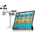
BRESSER 8-Tage 4CAST XL 7003230
these sensors are in use
count
Temperature
ventilated radiation shield
1
Air Pressure
1
Precipitation
1
Anemometer
mounting height: 31.17 ft
1
UV
1
Solar radiation
1
To map
Compare values with adjacent stations
To instrument page of the station
Sponsoring
MEMBERS
18002 Members at this time
13078 stations online
New stations:
heckfeld
Lewiston Michigan
Vaterstetten Baldham
Burgdamm Bremen
Döbeln_Großsteinbach
Weather Report
Cuers
heavy cloud / 64.9°F -
Big Canoe, GA
overcast sky / 75.9°F -
Current Warnings
no warnings at the moment
Minimum/ Maximum
Temperature
Phoenix-Foothills,AZ
111.2°F -
Jungfraujoch MCH
26.4°F -
Wind Speed
Mont Aigoual MF
30.6 mph - N -
Precipitation
Santa Fe, TX
3.4 in -
Visitors today: 166
currently 9 visitors on AWEKAS
Display Settings
Language
German
English
Dutch
French
Italian
Spanish
Measurement Units
Metric system
American system