Home
Weather Maps
Tables
Forum
Community
Service
Shop
My AWEKAS
AWEKAS Home
AWEKAS Mobile Home
Data protection
Imprint
Weather overview
Temperature
Air Pressure
Wind
Precipitation
Snow
Webcam
Sun
Dew point
Humidity
Current weather data
Current weather situation
Current weather warnings
Forum overview
News
Help and instructions
Wishes and suggestions
Register new
Memberlist
Member Map
Donations to AWEKAS
Banner and logo
Weather widget
AWEKAS shop
My station panel
Instrument designer
Stationsweb
Change user data
Report your weather
Data import/export
AWEKAS Benutzer:
login
Nearest stations
Information for station Wörth-Kranerberg
Aschheim
Ebersberg-Halbing DW
Ebersberg-Reith
Feldkirchen
Garching
Haar (Obb.)
Hallbergmoos-Goldach
Isen/Obb.
Ismaning
Ismaning-Süd
Markt Schwaben
Moosinning-Eching
Moosinning-Eichenrd.
München-Daglfing
München-Flugh. DWD
München-Riem
München-Riem II
Neuhausen, Erding
Neukeferloh
Oberdorfen
Pliening
St. Wolfgang (Obb.)
St.Wolfgang
Unterföhring
Vaterstetten
Vaterstetten Baldham
Wörth-Hörlkofen
Zorneding
Zorneding II
Station name
Wörth-Kranerberg
Country
Germany
Height above sea level
510 m
Geographical position
11° 52' 56.03'' East / 48° 14' 5.89'' North
Data transfer
Bresser Fastlink
Last updated
15.2.2026 10:40
AWEKAS Plus
YES
AWEKAS id
25015
Stations blog
edit
no station blog available
Information for station
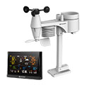
Type of station
BRESSER WLAN Comfort 7003300
these sensors are in use
count
Temperature
1
Precipitation
1
Anemometer
mounting height: 1 m
1
UV
1
Solar radiation
1
Soil temperature
4
Soil moisture
4
Leaf wetness
2
To map
Compare values with adjacent stations
To instrument page of the station
Sponsoring
MEMBERS
20022 Members at this time
14056 stations online
New stations:
Malgrat de Mar
Griesingen
Landau an der Isar
Grosselfingen
Rothenthal
Weather Report
Viviers
sunny sky / 4.4°C -
Hoofddorp (PAX)
sunny sky -
Current Warnings
no warnings at the moment
Minimum/ Maximum
Temperature
Papagou
38.3°C -
Storsätern
-22.6°C -
Wind Speed
Mont Aigoual MF
99km/h - N -
Precipitation
Crawinkel II
271.2 l/m² -
Visitors today: 2839
currently 61 visitors on AWEKAS
Display Settings
Language
German
English
Dutch
French
Italian
Spanish
Measurement Units
Metric system
American system