Home
Weather Maps
Tables
Forum
Community
Service
Shop
My AWEKAS
AWEKAS Home
AWEKAS Mobile Home
Data protection
Imprint
Weather overview
Temperature
Air Pressure
Wind
Precipitation
Snow
Webcam
Sun
Dew point
Humidity
Current weather data
Current weather situation
Current weather warnings
Forum overview
News
Help and instructions
Wishes and suggestions
Register new
Memberlist
Member Map
Donations to AWEKAS
Banner and logo
Weather widget
AWEKAS shop
My station panel
Instrument designer
Stationsweb
Change user data
Report your weather
Data import/export
AWEKAS Benutzer:
login
Nearest stations
Information for station Klosterlechfeld
Bobingen-Waldberg
Honsolgen
Hörbach i.Obb.
Pürgen
Schwabmünchen
St. Ottilien/Eresing
Türkenfeld
Türkheim
Wehringen
Station name
Klosterlechfeld
Country
Germany
Height above sea level
562 m
Geographical position
10° 49' 53'' East / 48° 9' 12'' North
Data transfer
Froggit Fastlink
Last updated
5/11/2024 8:45 am
AWEKAS Plus
YES
AWEKAS id
2639
Stations blog
edit
no station blog available
Information for station
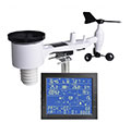
Type of station
Froggit WH4000SE
these sensors are in use
count
Temperature
1
Air Pressure
1
Precipitation
1
Anemometer
mounting height: 8.2 ft
1
UV
1
Solar radiation
1
To map
Compare values with adjacent stations
To instrument page of the station
Sponsoring
MEMBERS
11805 Members at this time
8717 stations online
New stations:
Oberjettingen
Châtel-Saint-Germain
Sainte-Pazanne
Zingst
Gugu
Weather Report
Tourrette-Levens
sunny sky / 65.7°F -
Chatel-Guyon
cloudy / 60.6°F -
Current Warnings
no warnings at the moment
Minimum/ Maximum
Temperature
Kanagala
97°F -
Gilpin County CO
30.7°F -
Wind Speed
Kionia - Tinos
42.2 mph - N -
Precipitation
Sussex Inlet
2.5 in -
Visitors today: 1171
currently 30 visitors on AWEKAS
Display Settings
Language
German
English
Dutch
French
Italian
Spanish
Measurement Units
Metric system
American system