Home
Weather Maps
Tables
Forum
Community
Service
Shop
My AWEKAS
AWEKAS Home
AWEKAS Mobile Home
Data protection
Imprint
Weather overview
Temperature
Air Pressure
Wind
Precipitation
Snow
Webcam
Sun
Dew point
Humidity
Current weather data
Current weather situation
Current weather warnings
Forum overview
News
Help and instructions
Wishes and suggestions
Register new
Memberlist
Member Map
Donations to AWEKAS
Banner and logo
Weather widget
AWEKAS shop
My station panel
Instrument designer
Stationsweb
Change user data
Report your weather
Data import/export
AWEKAS Benutzer:
login
Nearest stations
Information for station East Farleigh, Kent
Hollingbourne, Kent
Horsmonden,Broad Fd.
Lower Halstow
Sittingbourne
Tonbridge 1
Station name
East Farleigh, Kent
Country
Great Britain
Height above sea level
20 m
Geographical position
0° 28' 10'' East / 51° 15' 27'' North
Data transfer
Meteohub Direct Link
Last updated
1.10.2025 04:57
AWEKAS Plus
YES
AWEKAS id
7778
Stations blog
edit
no station blog available
Information for station
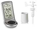
Type of station
Oregon Scientific WMR 100
these sensors are in use
count
Temperature
1
Air Pressure
1
Precipitation
1
Anemometer
mounting height: 2 m
1
UV
1
Link to station website East Farleigh, Kent
To map
Compare values with adjacent stations
To instrument page of the station
Sponsoring
MEMBERS
18184 Members at this time
12559 stations online
New stations:
Berlin Spandau
Freren Saller See
Rizal Antipolo City
Reutte1
Schaafheim
Weather Report
Reichmannsdorf
clear / 1.9°C -
Hartberg / Kroisbach
cloudy / 6.2°C -
Current Warnings
no warnings at the moment
Minimum/ Maximum
Temperature
La Tontouta MF
32.6°C -
Brunnenkogel / Oetzt
-9.8°C -
Wind Speed
Hvolsvöllur
46.4km/h - E -
Precipitation
Cedar Rapids, IA
117 l/m² -
Visitors today: 1469
currently 35 visitors on AWEKAS
Display Settings
Language
German
English
Dutch
French
Italian
Spanish
Measurement Units
Metric system
American system