Home
Weather Maps
Tables
Forum
Community
Service
Shop
My AWEKAS
AWEKAS Home
AWEKAS Mobile Home
Data protection
Imprint
Weather overview
Temperature
Air Pressure
Wind
Precipitation
Snow
Webcam
Sun
Dew point
Humidity
Current weather data
Current weather situation
Current weather warnings
Forum overview
News
Help and instructions
Wishes and suggestions
Register new
Memberlist
Member Map
Donations to AWEKAS
Banner and logo
Weather widget
AWEKAS shop
My station panel
Instrument designer
Stationsweb
Change user data
Report your weather
Data import/export
AWEKAS Benutzer:
login
Nearest stations
Information for station Rohr
Aulendorf
Aulendorf-Steegersee
Bad Wurzach/Arnach
BadWurzach-Dietmanns
Baienfurt
Leutkirch DWD
Otterswang
Ravensburg
Schlier
Schlier/Oberschwaben
Waldburg im Allgäu
Waldsee, Bad-Reute
Weingarten DWD
Weingarten-Lerchenf.
Station name
Rohr
Country
Germany
Height above sea level
666 m
Geographical position
9° 50' 14.58'' East / 47° 52' 11.47'' North
Data transfer
Bresser Fastlink
Last updated
29.10.2025 15:41
AWEKAS Plus
YES
AWEKAS id
48173
Stations blog
edit
no station blog available
Information for station
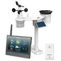
Type of station
BRESSER MeteoChamp HD 7003510
To map
Compare values with adjacent stations
To instrument page of the station
Sponsoring
MEMBERS
18290 Members at this time
13214 stations online
New stations:
Nagold - Hochdorf
München-Allach II
Waldbach Rablkreuz
Rettenegg Wechsel
Las Rozas de Madrid
Weather Report
Hartberg / Kroisbach
sunny sky / 17.7°C -
Bourg-Saint-Bernard
heavy cloud / 17.2°C -
Current Warnings
no warnings at the moment
Minimum/ Maximum
Temperature
Macouba-potiche MF
34.4°C -
Westcliffe-Silver CO
-11.2°C -
Wind Speed
Patscherkofel
81.7km/h - S -
Precipitation
Sevilla Bami
122.7 l/m² -
Visitors today: 4341
currently 38 visitors on AWEKAS
Display Settings
Language
German
English
Dutch
French
Italian
Spanish
Measurement Units
Metric system
American system