Home
Weather Maps
Tables
Forum
Community
Service
Shop
My AWEKAS
AWEKAS Home
AWEKAS Mobile Home
Data protection
Imprint
Weather overview
Temperature
Air Pressure
Wind
Precipitation
Snow
Webcam
Sun
Dew point
Humidity
Current weather data
Current weather situation
Current weather warnings
Forum overview
News
Help and instructions
Wishes and suggestions
Register new
Memberlist
Member Map
Donations to AWEKAS
Banner and logo
Weather widget
AWEKAS shop
My station panel
Instrument designer
Stationsweb
Change user data
Report your weather
Data import/export
AWEKAS Benutzer:
login
Nearest stations
Information for station Ingelheim
Armsheim
Aspisheim
Aspisheim 1
Bad Kreuznach
Budenheim (Rhein)
Budenheim am Rhein
Gau-Algesheim
Geisenheim DWD
Kiedrich
Klein-Winternheim
Kreuznach DWD
Langenlonsheim
Langenseifen
Mainz Bretzenheim 2
Mainz-Bretzenheim
Mainz-Finthen
Mainz-Hartenberg
Mainz-Lerchenb. DWD
Ober-Olm
Ober-Olm/Bellem DWD
Oestrich-Winkel
Schierstein-Nord
Stadecken-Elsheim
Stephanshausen(Ghm.)
Taunusst.-Bleidenst.
Taunusstein-Bleid.
Wackernheim
Waldalgesheim Nord
Wiesbaden-Biebrich
Wiesbaden-Dotzheim
Station name
Ingelheim
Country
Germany
Height above sea level
30 m
Geographical position
8° 2' 6.95'' East / 49° 58' 19.49'' North
Data transfer
Bresser Fastlink
Last updated
20.8.2025 16:46
AWEKAS Plus
YES
AWEKAS id
47555
Stations blog
edit
no station blog available
Information for station
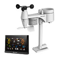
Type of station
BRESSER WLAN Comfort 7003300
these sensors are in use
count
Temperature
1
Air Pressure
1
Precipitation
1
Anemometer
mounting height: 3 m
1
UV
1
Solar radiation
1
To map
Compare values with adjacent stations
To instrument page of the station
Sponsoring
MEMBERS
18209 Members at this time
13192 stations online
New stations:
Ciney_Achêne_Fays
Merklingen (Alb)
Hamm-Heessen
Nedre Bäck
Großhau
Weather Report
Cuers
cloudy / 21°C -
Hartberg / Kroisbach
cloudy / 18.5°C -
Current Warnings
no warnings at the moment
Minimum/ Maximum
Temperature
Skemerhoek (Akanous)
38.1°C -
Hersey, MI
-2.6°C -
Wind Speed
Lower Bollihope
60km/h - NE -
Precipitation
San Vicent d Raspeig
57.6 l/m² -
Visitors today: 6584
currently 49 visitors on AWEKAS
Display Settings
Language
German
English
Dutch
French
Italian
Spanish
Measurement Units
Metric system
American system