Home
Weather Maps
Tables
Forum
Community
Service
Shop
My AWEKAS
AWEKAS Home
AWEKAS Mobile Home
Data protection
Imprint
Weather overview
Temperature
Air Pressure
Wind
Precipitation
Snow
Webcam
Sun
Dew point
Humidity
Current weather data
Current weather situation
Current weather warnings
Forum overview
News
Help and instructions
Wishes and suggestions
Register new
Memberlist
Member Map
Donations to AWEKAS
Banner and logo
Weather widget
AWEKAS shop
My station panel
Instrument designer
Stationsweb
Change user data
Report your weather
Data import/export
AWEKAS Benutzer:
login
Nearest stations
Information for station Chemin De Ceintur MF
Bagatelle_sapc MF
Beauvallon MF
Bellecombe-jacob MF
Bellevue Bras-pan MF
Belouve_sapc MF
Bois-rouge MF
Bras-pistolet_sap MF
Commerson_sapc MF
Gros Piton Sainte MF
Hauts De Sainte-r MF
Ilet A Vidot_sapc MF
Mare A Vieille Pl MF
Menciol MF
Plaine Des Cafres MF
Plaine Des Palmis MF
Saint-benoit MF
Salazie-village_s MF
Takamaka MF
Station name
Chemin De Ceintur MF
Country
France
Height above sea level
255 m
Geographical position
55° 41' 7.8'' East / 21° 4' 34.8'' South
Data transfer
manuell
Last updated
4.10.2025 09:00
AWEKAS Plus
YES
AWEKAS id
47010
Stations blog
edit
no station blog available
Information for station
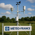
Type of station
Meteo France Wetterstation
these sensors are in use
count
Temperature
1
Air Pressure
1
Precipitation
1
Anemometer
mounting height: 3 m
1
UV
1
Solar radiation
1
Soil temperature
4
Link to station website Chemin De Ceintur MF
To map
Compare values with adjacent stations
To instrument page of the station
Sponsoring
MEMBERS
18188 Members at this time
13125 stations online
New stations:
Kirchberg/Pielach
Beausoleil
Neuhermsheim
Lincoln
Bohlsen
Weather Report
Sibenik-Krvavice
partly cloudy / 11.9°C -
Kennewick, WA
clear / 14.1°C -
Current Warnings
Brachelen
squalls
Minimum/ Maximum
Temperature
Kanagala
35.6°C -
Steinhaus am Semm.
-3.9°C -
Wind Speed
Brocken DWD
85.7km/h - SW -
Precipitation
Tonezza d.C.-Campana
457.4 l/m² -
Visitors today: 5237
currently 79 visitors on AWEKAS
Display Settings
Language
German
English
Dutch
French
Italian
Spanish
Measurement Units
Metric system
American system