Home
Weather Maps
Tables
Forum
Community
Service
Shop
My AWEKAS
AWEKAS Home
AWEKAS Mobile Home
Data protection
Imprint
Weather overview
Temperature
Air Pressure
Wind
Precipitation
Snow
Webcam
Sun
Dew point
Humidity
Current weather data
Current weather situation
Current weather warnings
Forum overview
News
Help and instructions
Wishes and suggestions
Register new
Memberlist
Member Map
Donations to AWEKAS
Banner and logo
Weather widget
AWEKAS shop
My station panel
Instrument designer
Stationsweb
Change user data
Report your weather
Data import/export
AWEKAS Benutzer:
login
Nearest stations
Information for station Pellafol-chaneaux MF
Agnieres-en-devol MF
Gap - Valjouffrey
La Mure- Radome MF
Lus L Croix Hte MF
Motte-molines MF
St Firmin MF
St-baudille MF
Valjouffrey_sapc MF
Villar Loubiere MF
Station name
Pellafol-chaneaux MF
Country
France
Height above sea level
947 m
Geographical position
5° 54' 22.2'' East / 44° 47' 3'' North
Data transfer
manuell
Last updated
15.10.2025 13:12
AWEKAS Plus
YES
AWEKAS id
45927
Stations blog
edit
no station blog available
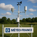
Information for station
Type of station
Meteo France Wetterstation
these sensors are in use
count
Temperature
1
Air Pressure
1
Precipitation
1
Anemometer
mounting height: 3 m
1
UV
1
Solar radiation
1
Soil temperature
4
Link to station website Pellafol-chaneaux MF
To map
Compare values with adjacent stations
To instrument page of the station
Sponsoring
MEMBERS
18234 Members at this time
13178 stations online
New stations:
Schmallenberg
Kaarst Staakerseite
St-martin Marigot MF
Wurdach
smaragdstraat 50
Weather Report
Harstad-Høghaugen
rain / 9.7°C -
Reichmannsdorf
light rain / 9.6°C -
Current Warnings
no warnings at the moment
Minimum/ Maximum
Temperature
Rustenburg
34.5°C -
Darfield, BC
-3.3°C -
Wind Speed
La Chiappa MF
48.6km/h - NE -
Precipitation
Olbia Cugnana
57.2 l/m² -
Visitors today: 3152
currently 40 visitors on AWEKAS
Display Settings
Language
German
English
Dutch
French
Italian
Spanish
Measurement Units
Metric system
American system