Home
Weather Maps
Tables
Forum
Community
Service
Shop
My AWEKAS
AWEKAS Home
AWEKAS Mobile Home
Data protection
Imprint
Weather overview
Temperature
Air Pressure
Wind
Precipitation
Snow
Webcam
Sun
Dew point
Humidity
Current weather data
Current weather situation
Current weather warnings
Forum overview
News
Help and instructions
Wishes and suggestions
Register new
Memberlist
Member Map
Donations to AWEKAS
Banner and logo
Weather widget
AWEKAS shop
My station panel
Instrument designer
Stationsweb
Change user data
Report your weather
Data import/export
AWEKAS Benutzer:
login
Nearest stations
Information for station Lus L Croix Hte MF
Agnieres-en-devol MF
Chichilianne_sapc MF
Glandage_sapc MF
La Faurie MF
Pellafol-chaneaux MF
St-baudille MF
Veynes MF
Station name
Lus L Croix Hte MF
Country
France
Height above sea level
1059 m
Geographical position
5° 42' 39'' East / 44° 40' 22.2'' North
Data transfer
manuell
Last updated
9/28/2025 11:00 am
AWEKAS Plus
YES
AWEKAS id
45689
Stations blog
edit
no station blog available
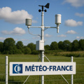
Information for station
Type of station
Meteo France Wetterstation
these sensors are in use
count
Temperature
1
Air Pressure
1
Precipitation
1
Anemometer
mounting height: 9.84 ft
1
UV
1
Solar radiation
1
Soil temperature
4
Link to station website Lus L Croix Hte MF
To map
Compare values with adjacent stations
To instrument page of the station
Sponsoring
MEMBERS
18176 Members at this time
13190 stations online
New stations:
Bourges
Larochette
Karymshina
Ste-anne Marly MF
Grasse 4 chemins
Weather Report
Albertville
cloudy / 66.4°F -
Big Canoe, GA
overcast sky / 66.2°F -
Current Warnings
no warnings at the moment
Minimum/ Maximum
Temperature
Kanagala
91.9°F -
Zugspitze DWD
26.2°F -
Wind Speed
Poingam MF
26.6 mph - E -
Precipitation
Silva Escura
2.2 in -
Visitors today: 2702
currently 38 visitors on AWEKAS
Display Settings
Language
German
English
Dutch
French
Italian
Spanish
Measurement Units
Metric system
American system