Home
Weather Maps
Tables
Forum
Community
Service
Shop
My AWEKAS
AWEKAS Home
AWEKAS Mobile Home
Data protection
Imprint
Weather overview
Temperature
Air Pressure
Wind
Precipitation
Snow
Webcam
Sun
Dew point
Humidity
Current weather data
Current weather situation
Current weather warnings
Forum overview
News
Help and instructions
Wishes and suggestions
Register new
Memberlist
Member Map
Donations to AWEKAS
Banner and logo
Weather widget
AWEKAS shop
My station panel
Instrument designer
Stationsweb
Change user data
Report your weather
Data import/export
AWEKAS Benutzer:
login
Nearest stations
Information for station Neer
Brüggen-Genrohe
Echt
Grubbenvorst
Helden-Dörp
Heythuysen
Hulsforthof
Linne
Mofert
Montfort
Montfort zuid
Nederweert-Eind
Nettetal-Kaldenk.
Nettetal-Lobberich
Niederkrüchten Elmpt
Niederkrüchten-Oberk
Pey-dorp
Reuver
Reuver West
Roermond
Schwalmtal Waldniel
Sint Odiliënberg
Tegelen
Venlo - Schoolweg
Venlot Ven Mariadal
Vlodrop
Wassenberg Birgelen
Station name
Neer
Country
Netherlands
Height above sea level
27 m
Geographical position
5° 59' 30.77'' East / 51° 15' 42.01'' North
Data transfer
Bresser Fastlink
Last updated
1/4/2026 3:42 am
AWEKAS Plus
YES
AWEKAS id
45108
Stations blog
edit
no station blog available
Information for station
Type of station
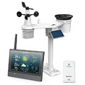
BRESSER MeteoChamp HD 7003510
these sensors are in use
count
Temperature
1
Air Pressure
1
Precipitation
1
Anemometer
mounting height: 5.58 ft
1
UV
1
Solar radiation
1
Soil temperature
2
To map
Compare values with adjacent stations
To instrument page of the station
Sponsoring
MEMBERS
19792 Members at this time
13943 stations online
New stations:
Poortvliet Zld
Rotheau
Pamhagen
Gäufelden
Columbia, TN
Weather Report
Cuers
heavy cloud / 38.7°F -
Sibenik-Krvavice
overcast sky / 53.4°F -
Current Warnings
no warnings at the moment
Minimum/ Maximum
Temperature
Beelbangera, NSW
100°F -
Slagnäs, Gasa
-26.3°F -
Wind Speed
Brocken DWD
42.1 mph - W -
Precipitation
Placerville, CA
1.6 in -
Visitors today: 488
currently 11 visitors on AWEKAS
Display Settings
Language
German
English
Dutch
French
Italian
Spanish
Measurement Units
Metric system
American system