Home
Weather Maps
Tables
Forum
Community
Service
Shop
My AWEKAS
AWEKAS Home
AWEKAS Mobile Home
Data protection
Imprint
Weather overview
Temperature
Air Pressure
Wind
Precipitation
Snow
Webcam
Sun
Dew point
Humidity
Current weather data
Current weather situation
Current weather warnings
Forum overview
News
Help and instructions
Wishes and suggestions
Register new
Memberlist
Member Map
Donations to AWEKAS
Banner and logo
Weather widget
AWEKAS shop
My station panel
Instrument designer
Stationsweb
Change user data
Report your weather
Data import/export
AWEKAS Benutzer:
login
Nearest stations
Information for station
Station name
Country
Height above sea level
m
Geographical position
° ' '' East / ° ' '' North
Data transfer
Last updated
1/1/1970 1:00 am
AWEKAS Plus
NO
AWEKAS id
44876
Stations blog
edit
no station blog available
Information for station
Type of station
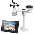
BRESSER WLAN WSC 5-in-1 (7003360)
these sensors are in use
count
Temperature
1
Air Pressure
1
Precipitation
1
Anemometer
mounting height: 6.56 ft
1
UV
1
Solar radiation
1
Soil temperature
4
Soil moisture
4
Leaf wetness
2
To map
Compare values with adjacent stations
To instrument page of the station
Sponsoring
MEMBERS
18265 Members at this time
13208 stations online
New stations:
Sun Valley
Föderlach
Ottenschlag
Tulln an der Donau
Stockham
Weather Report
Reichmannsdorf
light rain / 43.2°F -
Viviers
heavy cloud / 52°F -
Current Warnings
no warnings at the moment
Minimum/ Maximum
Temperature
Gral Bustos Cordoba
98.8°F -
Aiguille Du Midi MF
8.6°F -
Wind Speed
Brocken DWD
51.9 mph - SW -
Precipitation
Bocognano-gare MF
5.7 in -
Visitors today: 9817
currently 52 visitors on AWEKAS
Display Settings
Language
German
English
Dutch
French
Italian
Spanish
Measurement Units
Metric system
American system