Home
Weather Maps
Tables
Forum
Community
Service
Shop
My AWEKAS
AWEKAS Home
AWEKAS Mobile Home
Data protection
Imprint
Weather overview
Temperature
Air Pressure
Wind
Precipitation
Snow
Webcam
Sun
Dew point
Humidity
Current weather data
Current weather situation
Current weather warnings
Forum overview
News
Help and instructions
Wishes and suggestions
Register new
Memberlist
Member Map
Donations to AWEKAS
Banner and logo
Weather widget
AWEKAS shop
My station panel
Instrument designer
Stationsweb
Change user data
Report your weather
Data import/export
AWEKAS Benutzer:
login
Nearest stations
Information for station Ahrweiler DWD
Alfter Witterschlick
B.Münstereif.-Eichen
B.Münstereifel-Wald
Bell-Ost
Bonn-Bad Godesberg
Bonn-Dottendorf
Bonn-Lengsdorf
Burgbrohl, Weiler
Flamersheim
Hilterscheid
Meckenheim
Meckenheim Rhld.
Morenhoven
Niederzissen
Oberzissen
Odendorf
Ohlenberg-Obererl
Pitscheid
Remagen
Rheinbach Höhenort
Sinzig
Vettelschoß-Kau
Wachtberg
Wachtberg-Werthhoven
Station name
Ahrweiler DWD
Country
Germany
Height above sea level
111 m
Geographical position
7° 5' 7.08'' East / 50° 32' 4.56'' North
Data transfer
manuell
Last updated
12/4/2025 4:50 pm
AWEKAS Plus
YES
AWEKAS id
44226
Stations blog
edit
no station blog available
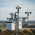
Information for station
Type of station
DWD-Wetterstation
these sensors are in use
count
Temperature
1
Air Pressure
1
Precipitation
1
Anemometer
mounting height: 9.84 ft
1
UV
1
Solar radiation
1
Soil temperature
4
Soil moisture
4
Leaf wetness
2
Link to station website Ahrweiler DWD
To map
Compare values with adjacent stations
To instrument page of the station
Sponsoring
MEMBERS
18450 Members at this time
13185 stations online
New stations:
Villar d los Barrios
Zweiersdorf
Schwelm Oberloh
Homberg/Efze
Burghausen
Weather Report
Chatel-Guyon
heavy cloud / 44.6°F -
Maroussi
heavy rain / 54.9°F -
Current Warnings
no warnings at the moment
Minimum/ Maximum
Temperature
Skemerhoek (Akanous)
102.6°F -
Winter, WI
-6.3°F -
Wind Speed
Mont Aigoual MF
36 mph - NW -
Precipitation
Barbaggio_sapc MF
4 in -
Visitors today: 4674
currently 38 visitors on AWEKAS
Display Settings
Language
German
English
Dutch
French
Italian
Spanish
Measurement Units
Metric system
American system