Home
Weather Maps
Tables
Forum
Community
Service
Shop
My AWEKAS
AWEKAS Home
AWEKAS Mobile Home
Data protection
Imprint
Weather overview
Temperature
Air Pressure
Wind
Precipitation
Snow
Webcam
Sun
Dew point
Humidity
Current weather data
Current weather situation
Current weather warnings
Forum overview
News
Help and instructions
Wishes and suggestions
Register new
Memberlist
Member Map
Donations to AWEKAS
Banner and logo
Weather widget
AWEKAS shop
My station panel
Instrument designer
Stationsweb
Change user data
Report your weather
Data import/export
AWEKAS Benutzer:
login
Nearest stations
Information for station Fürnsal
Alpirsbach Reutin
Altoberndorf
Baiersbr.-Heselbach
Dietersweiler
Dornhan
Dornstetten-Hallwgn.
Fluorn-Winzeln
Freudenstadt DWD
Haiterbach
Hochmössingen
Hopfau
Loßburg-Betzweiler
Lossburg
Musbach
Oberndorf-Aistaig
Schiltach
Schrambg-Waldmössgn.
Waldachtal
Waldachtal-Tumlingen
Wittlensweiler-Halde
Station name
Fürnsal
Country
Germany
Height above sea level
600 m
Geographical position
8° 31' 4.94'' East / 48° 22' 34.47'' North
Data transfer
Bresser Fastlink
Last updated
7.8.2025 23:19
AWEKAS Plus
YES
AWEKAS id
43986
Stations blog
edit
no station blog available
Information for station
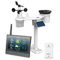
Type of station
BRESSER MeteoChamp HD 7003510
these sensors are in use
count
Temperature
1
Air Pressure
1
Precipitation
1
Anemometer
mounting height: 4 m
1
UV
1
Solar radiation
1
Soil temperature
2
Soil moisture
1
To map
Compare values with adjacent stations
To instrument page of the station
Sponsoring
MEMBERS
17920 Members at this time
12555 stations online
New stations:
Oberau/Loisach
Müllheim TG
Kölzin
Capesterre-m-gala MF
InishBofin Island
Weather Report
Big Canoe, GA
partly cloudy / 22.7°C -
Halesowen
rain / 17.1°C -
Current Warnings
no warnings at the moment
Minimum/ Maximum
Temperature
Phoenix-Foothills,AZ
47.3°C -
Ensay
-2.9°C -
Wind Speed
Lerwick
54.1km/h - SW -
Precipitation
Homestead, FL
69.5 l/m² -
Visitors today: 6853
currently 27 visitors on AWEKAS
Display Settings
Language
German
English
Dutch
French
Italian
Spanish
Measurement Units
Metric system
American system