Home
Weather Maps
Tables
Forum
Community
Service
Shop
My AWEKAS
AWEKAS Home
AWEKAS Mobile Home
Data protection
Imprint
Weather overview
Temperature
Air Pressure
Wind
Precipitation
Snow
Webcam
Sun
Dew point
Humidity
Current weather data
Current weather situation
Current weather warnings
Forum overview
News
Help and instructions
Wishes and suggestions
Register new
Memberlist
Member Map
Donations to AWEKAS
Banner and logo
Weather widget
AWEKAS shop
My station panel
Instrument designer
Stationsweb
Change user data
Report your weather
Data import/export
AWEKAS Benutzer:
login
Nearest stations
Information for station Benningbroek
Broek Op Langedijk
De Draai (HHW Oost)
DeGoorn
Heerhugowaard Zuid
Hoorn NH
Medemblik
Oudkarspel
Tuitjenhorn
Zuid Scharwoude
Zwaag
Station name
Benningbroek
Country
Netherlands
Height above sea level
-2 m
Geographical position
5° 0' 51.61'' East / 52° 42' 16.48'' North
Data transfer
Bresser Fastlink
Last updated
8/19/2025 11:15 pm
AWEKAS Plus
YES
AWEKAS id
39599
Stations blog
edit
no station blog available
Information for station
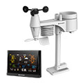
Type of station
BRESSER WLAN Comfort 7003300
these sensors are in use
count
Temperature
1
Air Pressure
1
Precipitation
1
Anemometer
:
1
UV
1
Solar radiation
1
Soil temperature
4
Soil moisture
4
Leaf wetness
2
To map
Compare values with adjacent stations
To instrument page of the station
Sponsoring
MEMBERS
17987 Members at this time
13076 stations online
New stations:
Untertoellern
Clinton Bluff
Strettoia
Lohmen 02
Sorgenlos
Weather Report
Albertville
heavy cloud / 70°F -
Viviers
heavy cloud / 71.4°F -
Current Warnings
no warnings at the moment
Minimum/ Maximum
Temperature
Glendale-Westerra,AZ
110.7°F -
Ensay
26.8°F -
Wind Speed
Troyan
49.5 mph - NE -
Precipitation
Hauts De Sainte-r MF
5.7 in -
Visitors today: 8451
currently 35 visitors on AWEKAS
Display Settings
Language
German
English
Dutch
French
Italian
Spanish
Measurement Units
Metric system
American system