Home
Weather Maps
Tables
Forum
Community
Service
Shop
My AWEKAS
AWEKAS Home
AWEKAS Mobile Home
Data protection
Imprint
Weather overview
Temperature
Air Pressure
Wind
Precipitation
Snow
Webcam
Sun
Dew point
Humidity
Current weather data
Current weather situation
Current weather warnings
Forum overview
News
Help and instructions
Wishes and suggestions
Register new
Memberlist
Member Map
Donations to AWEKAS
Banner and logo
Weather widget
AWEKAS shop
My station panel
Instrument designer
Stationsweb
Change user data
Report your weather
Data import/export
AWEKAS Benutzer:
login
Nearest stations
Information for station Ter Apel
Barger Compascuum
Barger-Oosterveld
Emmen Zuid-West
Gasselternijveen
Haren-Altenberge
Haren-Emmeln
Lathen-Dünefehn
Musselkanaal
Nieuw-Weerdinge
Sellingen-Overdiep
Ter Apel, T Schot
Vlagtwedde
Station name
Ter Apel
Country
Netherlands
Height above sea level
3 m
Geographical position
7° 3' 53.89'' East / 52° 53' 1.54'' North
Data transfer
Bresser Fastlink
Last updated
9.5.2024 09:48
AWEKAS Plus
YES
AWEKAS id
35676
Stations blog
edit
no station blog available
Information for station
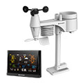
Type of station
BRESSER WLAN Comfort 7003300
these sensors are in use
count
Temperature
1
Air Pressure
1
Precipitation
1
Anemometer
mounting height: 3 m
1
UV
1
Solar radiation
1
To map
Compare values with adjacent stations
To instrument page of the station
Sponsoring
MEMBERS
11796 Members at this time
8768 stations online
New stations:
Cacouna
Mérida Sur
Cottbus-Sielow
Ilmenau
Schlag 24
Weather Report
Tourrette-Levens
sunny sky / 19.8°C -
Sibenik-Krvavice
clear / 22.1°C -
Current Warnings
no warnings at the moment
Minimum/ Maximum
Temperature
Caloocan PH
34.6°C -
Westcliffe-Silver CO
-5.6°C -
Wind Speed
Tarifa
46.8km/h - E -
Precipitation
Brevard, NC
40.6 l/m² -
Visitors today: 1800
currently 34 visitors on AWEKAS
Display Settings
Language
German
English
Dutch
French
Italian
Spanish
Measurement Units
Metric system
American system