Home
Weather Maps
Tables
Forum
Community
Service
Shop
My AWEKAS
AWEKAS Home
AWEKAS Mobile Home
Data protection
Imprint
Weather overview
Temperature
Air Pressure
Wind
Precipitation
Snow
Webcam
Sun
Dew point
Humidity
Current weather data
Current weather situation
Current weather warnings
Forum overview
News
Help and instructions
Wishes and suggestions
Register new
Memberlist
Member Map
Donations to AWEKAS
Banner and logo
Weather widget
AWEKAS shop
My station panel
Instrument designer
Stationsweb
Change user data
Report your weather
Data import/export
AWEKAS Benutzer:
login
Nearest stations
Information for station Lichtenvoorde
AG Halle
Ammeloe NRW
Bocholt Barlo
Bocholt Ost 2
Bocholt-Giethorst
Bocholt-Ost
Bredevoort
Doetinchem-Oost
Groenlo I
Groenlo Zuid
Mussum
Rhede
Silvolde
Varsseveld
Winterswijk
Winterswijk Woold
Station name
Lichtenvoorde
Country
Netherlands
Height above sea level
19 m
Geographical position
6° 33' 20.48'' East / 51° 58' 55.21'' North
Data transfer
Bresser Fastlink
Last updated
13.10.2025 23:13
AWEKAS Plus
YES
AWEKAS id
31408
Stations blog
edit
no station blog available
Information for station
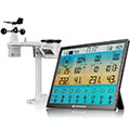
Type of station
BRESSER 8-Tage 4CAST XL 7003230
these sensors are in use
count
Temperature
1
Air Pressure
1
Precipitation
1
Anemometer
mounting height: 3 m
1
UV
1
Solar radiation
1
Soil moisture
4
Leaf wetness
2
To map
Compare values with adjacent stations
To instrument page of the station
Sponsoring
MEMBERS
18229 Members at this time
13179 stations online
New stations:
Wurdach
smaragdstraat 50
Salzburg Itzling
Fontaines
Noeleen Acres
Weather Report
Reichmannsdorf
clear / 5.7°C -
Sibenik-Krvavice
clear / 15.8°C -
Current Warnings
no warnings at the moment
Minimum/ Maximum
Temperature
San Jose del Cabo
33.5°C -
Aiguille Du Midi MF
-4.3°C -
Wind Speed
Gatteville Le P MF
49km/h - NE -
Precipitation
Wenatchee, WA
958.3 l/m² -
Visitors today: 6027
currently 13 visitors on AWEKAS
Display Settings
Language
German
English
Dutch
French
Italian
Spanish
Measurement Units
Metric system
American system