Home
Weather Maps
Tables
Forum
Community
Service
Shop
My AWEKAS
AWEKAS Home
AWEKAS Mobile Home
Data protection
Imprint
Weather overview
Temperature
Air Pressure
Wind
Precipitation
Snow
Webcam
Sun
Dew point
Humidity
Current weather data
Current weather situation
Current weather warnings
Forum overview
News
Help and instructions
Wishes and suggestions
Register new
Memberlist
Member Map
Donations to AWEKAS
Banner and logo
Weather widget
AWEKAS shop
My station panel
Instrument designer
Stationsweb
Change user data
Report your weather
Data import/export
AWEKAS Benutzer:
login
Nearest stations
Information for station Pergkirchen
Abwinden
Arbing
B.Kreuzen-Kollroßdf.
Bad Kreuzen
Bad Kreuzen OÖ
Bad Kreuzen/Kreuzer
Bad Zell
Baumgartenberg
Dimbach (OÖ)
Dimbach/Gassen
Enns
Enns Geosphere
Enns Nord
Ernsthofen-Altenrath
Frensdorf - Wartberg
Frensdorf II
Grein Ponnegger
Grünau Ost (OÖ)
Haag/Salaberg
Hagenberg/Mühlkreis
Herzograd West
Klein Erla
Langenbach/Waldh.
Lehen
Marbach Ost
Mauthausen (OÖ)
Mitterkirchen
Mötlasberg
Naarn i. M.
Oberaschbach
Obereisendorf
Obervisnitz
Pabneukirchen
Pabneukirchen GS
Pabneukirchen Ma.Süd
Perg
Perg Lehenbrunn
Perg Poschachersdlg.
Perg Thurnhof
Pierbach
Pierbach-Meislberg
Rechberg-Puchberg
Ried in der Riedmark
Ruprechtshofen-Naarn
Schwertberg
Schwertberg, Winden
Schwertberg-Aiser
Stephanshart
Straß (OÖ)
Strengberg
Strengberg-Kleinhaag
Unter-Pabneukirchen
Viehdorf-Hochholz
Waldhausen Dörfl
Waldhausen/Eder
Waldhausen/Sattlgai
Waldhausen/Zeitlh.
Station name
Pergkirchen
Country
Austria
Height above sea level
329 m
Geographical position
14° 40' 37.42'' East / 48° 14' 39.75'' North
Data transfer
Bresser Fastlink
Last updated
9/29/2025 10:37 pm
AWEKAS Plus
YES
AWEKAS id
30482
Stations blog
edit
no station blog available
Information for station
Type of station
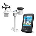
BRESSER 4-Tage 4CAST 7003200
these sensors are in use
count
Temperature
1
Air Pressure
1
Precipitation
1
Anemometer
mounting height: 8.2 ft
1
UV
1
Solar radiation
1
To map
Compare values with adjacent stations
To instrument page of the station
Sponsoring
MEMBERS
18185 Members at this time
13235 stations online
New stations:
Berlin Spandau
Freren Saller See
Rizal Antipolo City
Reutte1
Schaafheim
Weather Report
Kennewick, WA
clear / 74.8°F -
Hartberg / Kroisbach
cloudy / 51.3°F -
Current Warnings
no warnings at the moment
Minimum/ Maximum
Temperature
Spring 2, TX
95.7°F -
Brunnenkogel / Oetzt
23.4°F -
Wind Speed
Hvolsvöllur
31.7 mph - E -
Precipitation
Maset Tortosa
5.2 in -
Visitors today: 8676
currently 24 visitors on AWEKAS
Display Settings
Language
German
English
Dutch
French
Italian
Spanish
Measurement Units
Metric system
American system