Home
Weather Maps
Tables
Forum
Community
Service
Shop
My AWEKAS
AWEKAS Home
AWEKAS Mobile Home
Data protection
Imprint
Weather overview
Temperature
Air Pressure
Wind
Precipitation
Snow
Webcam
Sun
Dew point
Humidity
Current weather data
Current weather situation
Current weather warnings
Forum overview
News
Help and instructions
Wishes and suggestions
Register new
Memberlist
Member Map
Donations to AWEKAS
Banner and logo
Weather widget
AWEKAS shop
My station panel
Instrument designer
Stationsweb
Change user data
Report your weather
Data import/export
AWEKAS Benutzer:
login
Nearest stations
Information for station Velm
B.Sauerbr.-Keltenbg.
Bad Erlach
Bad Erlach Bahnhof
Bad Vöslau
Eggendorf (NÖ)
Enzesfeld
Felixdorf
Flatz (Ternitz)
Föhrenau (NÖ)
Föhrenau-Haderswörth
Forchtenstein Nord
Haschendorfer See
Hirm
Hohe Wand
Hornstein
Lanzenkirchen
Lichtenwörth
Lindabrunn
Lindabrunn Ost
Lindgrub/Natschbach
Maiersdorf
Markt Piesting
Mattersburg
Mattersburg Geosph.
Müllendorf
Neufeld a. d. Leitha
Neufeld a.d. Leitha
Neufelder See
Oberschlatten
Ödlitz
Pitten
Pottendorf
Pottendorf West
Pöttschinger See
Ramplach Neunkirchen
Siedl.Maria Theresia
Sigleß II
Sigleß Nord
Sollenau
Stollhof
Stöttera
Ternitz
Ternitz-Dunkelstein
Ternitz-Rohrbach
Thernberg
Thernberg II
Walbersdorf
Wiener Neustadt GS
Wimpassing-Leitha
Wr. Neustadt Raug.
Zillingtal 2
Zweiersdorf
Station name
Velm
Country
Austria
Height above sea level
171 m
Geographical position
16° 15' 44.56'' East / 47° 47' 35.73'' North
Data transfer
Bresser Fastlink
Last updated
1/10/2026 7:30 pm
AWEKAS Plus
YES
AWEKAS id
29308
Stations blog
edit
no station blog available
Information for station
Type of station
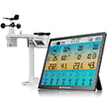
BRESSER 8-Tage 4CAST XL 7003230
these sensors are in use
count
Temperature
1
Precipitation
1
Anemometer
mounting height: 8.2 ft
1
UV
1
Solar radiation
1
Soil temperature
4
Soil moisture
4
Leaf wetness
2
To map
Compare values with adjacent stations
To instrument page of the station
Sponsoring
MEMBERS
19850 Members at this time
14269 stations online
New stations:
Montfaucon
St. Georgen a. W.
Lübeck
Boskruin
Vedrin
Weather Report
Kroisbach-Hartberg 2
snow / 30.6°F -
Kroisbach-Hartberg 3
snow / 30.9°F -
Current Warnings
no warnings at the moment
Minimum/ Maximum
Temperature
Manaus
91.9°F -
Port Alsworth, AK
-28.8°F -
Wind Speed
Luzzi CS
57 mph - SE -
Precipitation
Blue Ridge, GA
3.3 in -
Visitors today: 9034
currently 62 visitors on AWEKAS
Display Settings
Language
German
English
Dutch
French
Italian
Spanish
Measurement Units
Metric system
American system