Home
Weather Maps
Tables
Forum
Community
Service
Shop
My AWEKAS
AWEKAS Home
AWEKAS Mobile Home
Data protection
Imprint
Weather overview
Temperature
Air Pressure
Wind
Precipitation
Snow
Webcam
Sun
Dew point
Humidity
Current weather data
Current weather situation
Current weather warnings
Forum overview
News
Help and instructions
Wishes and suggestions
Register new
Memberlist
Member Map
Donations to AWEKAS
Banner and logo
Weather widget
AWEKAS shop
My station panel
Instrument designer
Stationsweb
Change user data
Report your weather
Data import/export
AWEKAS Benutzer:
login
Nearest stations
Information for station Lügde
Aerzen
Aerzen-Multhöpen
Aerzen-Reinerbeck
Barntrup-Alverdissen
Blomberg
Dörentrup-Humfeld
Dörentrup-Schwelent.
Hameln DWD
Hameln-Hastenbeck DW
Hameln-Nord
Hameln-Tündern
Herrentrup
Horn-B.MB-Billerbeck
Lügde DWD
Neersen
Polle
Steinheim Ost
Tündern
Station name
Lügde
Country
Germany
Height above sea level
105 m
Geographical position
9° 15' 1.44'' East / 51° 57' 39.89'' North
Data transfer
Bresser Fastlink
Last updated
26.11.2025 16:13
AWEKAS Plus
YES
AWEKAS id
25195
Stations blog
edit
no station blog available
Information for station
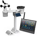
Type of station
BRESSER MeteoChamp 9-in-1 (7003520)
these sensors are in use
count
Temperature
1
Air Pressure
1
Precipitation
1
Anemometer
mounting height: 7 m
1
UV
1
Solar radiation
1
Soil temperature
4
Soil moisture
4
Leaf wetness
2
To map
Compare values with adjacent stations
To instrument page of the station
Sponsoring
MEMBERS
18407 Members at this time
13202 stations online
New stations:
Unterhautzental
St-claude Citerne MF
Innertal
Züschen
Ottenhöfen Zima
Weather Report
Hartberg / Kroisbach
heavy cloud / 6°C -
Sibenik-Krvavice
cloudy / 11.3°C -
Current Warnings
no warnings at the moment
Minimum/ Maximum
Temperature
Skemerhoek (Akanous)
38.1°C -
Aiguille Du Midi MF
-18.7°C -
Wind Speed
Mont Aigoual MF
73.4km/h - N -
Precipitation
Le Brule - Val Fl MF
51.6 l/m² -
Visitors today: 4915
currently 39 visitors on AWEKAS
Display Settings
Language
German
English
Dutch
French
Italian
Spanish
Measurement Units
Metric system
American system