Home
Weather Maps
Tables
Forum
Community
Service
Shop
My AWEKAS
AWEKAS Home
AWEKAS Mobile Home
Data protection
Imprint
Weather overview
Temperature
Air Pressure
Wind
Precipitation
Snow
Webcam
Sun
Dew point
Humidity
Current weather data
Current weather situation
Current weather warnings
Forum overview
News
Help and instructions
Wishes and suggestions
Register new
Memberlist
Member Map
Donations to AWEKAS
Banner and logo
Weather widget
AWEKAS shop
My station panel
Instrument designer
Stationsweb
Change user data
Report your weather
Data import/export
AWEKAS Benutzer:
login
Nearest stations
Information for station Lampertheim
Alsbach-Hähnlein
Altrip
Balzenbach
Beindersheim
Birkenau/Herrenwiese
Bobenheim
Bobenheim-Roxheim
Bobstadt
Bürstadt-Zentrum
E.-Neckarhausen
Gorxheimertal (SW)
Groß-Rohrheim
Heppenheim G-K-S
Heßheim
Lampertheim am Bruch
Lampertheim Nord
Laumersheim
Ludwigsh.-Mundenheim
Ludwigshafen
Ludwigshafen Maudach
MA-Herzogenried
MA-Kirschgartshausen
Mannheim - Schönau
Mannheim DWD
Mannheim Seckenheim
Mannheim-Gartenstadt
Mannheim-Sandhofen
Mannheim-Sandhofen 2
Mannheim-Sandhofen 3
Mörlenbach
Mutterstadt Nord
Neckarhausen
Neuhermsheim
Obrigheim(Pfalz)
Viernheim
Viernheim (Nordwest)
Weinheim West
Weinheim Weststadt
Weinheim-Süd
Weinheim/Bergstraße
Weisenheim am Sand
Westhofen
Worms
Worms DWD
Worms-Herrnsheim
Worms-Pfeddersheim
Station name
Lampertheim
Country
Germany
Height above sea level
92 m
Geographical position
8° 28' 18.43'' East / 49° 36' 6.35'' North
Data transfer
Bresser Fastlink
Last updated
23.7.2025 12:23
AWEKAS Plus
YES
AWEKAS id
23485
Stations blog
edit
no station blog available
Information for station
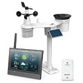
Type of station
BRESSER MeteoChamp HD 7003510
these sensors are in use
count
Temperature
ventilated radiation shield
1
Air Pressure
1
Precipitation
1
Anemometer
mounting height: 2.3 m
1
UV
1
Solar radiation
1
To map
Compare values with adjacent stations
To instrument page of the station
Sponsoring
MEMBERS
19900 Members at this time
13237 stations online
New stations:
48,580° N, 13,66 O
Petange Radio Poa
Lux Bridel
Kopstal
Harland_STP
Weather Report
Reichmannsdorf
clear / -0.8°C -
Buzignargues
drizzle / 8.7°C -
Current Warnings
no warnings at the moment
Minimum/ Maximum
Temperature
Yarragadee
38.2°C -
Anola, MB
-24.9°C -
Wind Speed
Le Dramont MF
90.4km/h - E -
Precipitation
Isolaccio Di Fium MF
60.9 l/m² -
Visitors today: 896
currently 38 visitors on AWEKAS
Display Settings
Language
German
English
Dutch
French
Italian
Spanish
Measurement Units
Metric system
American system