Home
Weather Maps
Tables
Forum
Community
Service
Shop
My AWEKAS
AWEKAS Home
AWEKAS Mobile Home
Data protection
Imprint
Weather overview
Temperature
Air Pressure
Wind
Precipitation
Snow
Webcam
Sun
Dew point
Humidity
Current weather data
Current weather situation
Current weather warnings
Forum overview
News
Help and instructions
Wishes and suggestions
Register new
Memberlist
Member Map
Donations to AWEKAS
Banner and logo
Weather widget
AWEKAS shop
My station panel
Instrument designer
Stationsweb
Change user data
Report your weather
Data import/export
AWEKAS Benutzer:
login
Nearest stations
Information for station Lehrte-Hämelerwald
Algermissen DWD
Algermissen West
Edemissen
Edemissen-Süd
Groß Lafferde
Hannover-Bemerode
Hannover-Kronsberg
Hannover-Misburg-N.
Harsum
Harsum-Nord
Hohenhameln
Ilsede-Solschen
Immensen
Laatzen
Lehrte Hämelerwald 2
Lengede Woltwiesche
Lengede-Broistedt
Oberg
Peine Süd
Peine-Essinghausen
Peine-Rosenthal
Peine-Stederdorf Ost
Peine-Vöhrum
Sarstedt-Hotteln
Schellerten-Dingelbe
Uetze
Uetze-Dedenhausen
Uetze-Eltze
Uetze-Schwüblingsen
Vechelde-Liedingen
Station name
Lehrte-Hämelerwald
Country
Germany
Height above sea level
79 m
Geographical position
10° 6' 49.88'' East / 52° 20' 56.04'' North
Data transfer
Froggit Fastlink
Last updated
20.11.2025 23:01
AWEKAS Plus
YES
AWEKAS id
21382
Stations blog
edit
no station blog available
Information for station
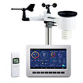
Type of station
Froggit HP1000SE PRO
these sensors are in use
count
Temperature
ventilated radiation shield
1
Air Pressure
1
Precipitation
1
Anemometer
mounting height: 2.6 m
1
UV
1
Solar radiation
1
To map
Compare values with adjacent stations
To instrument page of the station
Sponsoring
MEMBERS
18382 Members at this time
12873 stations online
New stations:
Marum
Santa Bernardina
Auerbach Oberpfalz
(A)-Sigless
Mil Palmeras
Weather Report
Reichmannsdorf
clear / -8.9°C -
Thessaloniki-Center
partly cloudy -
Current Warnings
no warnings at the moment
Minimum/ Maximum
Temperature
Pozo Castaño
40.7°C -
Slagnäs, Gasa
-26.8°C -
Wind Speed
Le Dramont MF
59km/h - W -
Precipitation
Sinies Porta (Corfu)
99.2 l/m² -
Visitors today: 8609
currently 55 visitors on AWEKAS
Display Settings
Language
German
English
Dutch
French
Italian
Spanish
Measurement Units
Metric system
American system