Facebook
 
 AWEKAS Benutzer: login  
Nearest stations  
Information for station Radnor
 
  Station name Radnor  
Country Great Britain   
Height above sea level 101 m
Geographical position     5° 12' 12.59'' West / 50° 15' 10.49'' North
Data transfer WU Fastlink
Last updated 4.8.2025 21:15
AWEKAS Plus YES  
AWEKAS id 20746
 
  Stations blog edit  
 

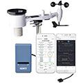
GW1002 station, anemometer at 6 metres

WS68 Anemometer (failed 13 Feb 23 replaced with WS80 ultrasonic  12 Mar 23), replacement WS80 failed 26 Dec 24, replaced 5Jan 25


GW1000 gateway unit failed 1-3 Apr, replaced with GW1100 5 Apr 25 at 1330


WH40 Rainfall Sensor
WH32 Outdoor Temperature and Humidity Sensor
GW 1000 WiFi Gateway
WH45 Indoor CO2 PM2.5 PM10 AQ Sensor


Information for station
station Type of station  Ecowitt GW1x00
these sensors are in use count
Temperature 1
Air Pressure 1
Precipitation 1
Anemometer mounting height: 6 m1


To map
Compare values with adjacent stations
To instrument page of the station
 
 
info
 
Sponsoring
MEMBERS
17902 Members at this time
12600 stations online
New stations:
Marigny Les Usages
Mureck Ost
Blaricummermeent
Nettetal-Lobberland
Hoensbroek
 
 
Weather Report
Northeast Tucson
 thunderstorm / 36.8°C -
Berlin
 sunny sky / 18°C -
no warnings at the moment
Minimum/ Maximum
Temperature

Glendale-Westerra,AZ
42.9°C -
Balfour
-4.9°C -
Wind Speed
Orphir, Orkney
72.4km/h - N -
Precipitation
Negovantsi
87.4 l/m² -
 
Visitors today: 7790
currently 47 visitors on AWEKAS
Display Settings
Language
German English
Dutch French
Italian Spanish
Measurement Units
Metric system
American system