Home
Weather Maps
Tables
Forum
Community
Service
Shop
My AWEKAS
AWEKAS Home
AWEKAS Mobile Home
Data protection
Imprint
Weather overview
Temperature
Air Pressure
Wind
Precipitation
Snow
Webcam
Sun
Dew point
Humidity
Current weather data
Current weather situation
Current weather warnings
Forum overview
News
Help and instructions
Wishes and suggestions
Register new
Memberlist
Member Map
Donations to AWEKAS
Banner and logo
Weather widget
AWEKAS shop
My station panel
Instrument designer
Stationsweb
Change user data
Report your weather
Data import/export
AWEKAS Benutzer:
login
Nearest stations
Information for station Porter Black Pond ME
Station name
Porter Black Pond ME
Country
USA
Height above sea level
131 m
Geographical position
70° 55' 24.78'' West / 43° 49' 51.45'' North
Data transfer
WU Fastlink
Last updated
3.9.2023 18:20
AWEKAS Plus
YES
AWEKAS id
18237
Stations blog
edit
no station blog available
Information for station
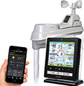
Type of station
AcuRite 01536
these sensors are in use
count
Temperature
ventilated radiation shield
1
Precipitation
1
Anemometer
mounting height: 6.1 m
1
UV
1
Solar radiation
1
Soil temperature
4
Soil moisture
4
Leaf wetness
2
To map
Compare values with adjacent stations
To instrument page of the station
Sponsoring
MEMBERS
19961 Members at this time
13324 stations online
New stations:
Schongau Altenstadt
Holzschlag
Ziegenhain
Frohnleiten Nord
Sitzendorf
Weather Report
Cuers
heavy cloud / 6.4°C -
Sibenik-Krvavice
overcast sky / 6.7°C -
Current Warnings
no warnings at the moment
Minimum/ Maximum
Temperature
Yoogali, NSW
45.7°C -
Sudbury, ON
-29.8°C -
Wind Speed
Mont Aigoual MF
80.3km/h - NW -
Precipitation
Jakarta
48.4 l/m² -
Visitors today: 834
currently 36 visitors on AWEKAS
Display Settings
Language
German
English
Dutch
French
Italian
Spanish
Measurement Units
Metric system
American system