Home
Weather Maps
Tables
Forum
Community
Service
Shop
My AWEKAS
AWEKAS Home
AWEKAS Mobile Home
Data protection
Imprint
Weather overview
Temperature
Air Pressure
Wind
Precipitation
Snow
Webcam
Sun
Dew point
Humidity
Current weather data
Current weather situation
Current weather warnings
Forum overview
News
Help and instructions
Wishes and suggestions
Register new
Memberlist
Member Map
Donations to AWEKAS
Banner and logo
Weather widget
AWEKAS shop
My station panel
Instrument designer
Stationsweb
Change user data
Report your weather
Data import/export
AWEKAS Benutzer:
login
Nearest stations
Information for station Bad Berleburg
Allendorf (Eder)
Aue-Wingeshausen
B.Bbg.-Diedenshausen
B.Bbg.-Sassenhausen
B.Bbg.-Schwarzenau
B.Bbg.-Weidenhausen
B.Berleb.-Berghausen
Bad Berleburg Zentr.
Bad Berleburg-Arfeld
Bad Berleburg-Elsoff
Bad Fredeburg
Bad Laasphe
BadBerleburg-Dotzlar
Battenberg-Dodenau
Birkelbach
Breidenbach
Bromskirchen-Somplar
Erndtebrück
Erndtebrück Benfe 2
Erndtebrück-Benfe
Hallenberg-West
Hallenbg.-Wunderthsn
Laaspherhütte
Neuastenberg
Niedersorpe
Rhein-Weser-Turm
Schm'b.,HoherKnochen
Schmallenb.-Wormbach
Schmallenberg, Gymn.
Schmallenbg-Jagdhaus
Schmallenbg-Nordenau
Schmallenbg-Westfeld
SchmallenbGrafschaft
Wingeshausen
Winterberg
Winterberg-Züschen
Station name
Bad Berleburg
Country
Germany
Height above sea level
475 m
Geographical position
8° 23' 47.49'' East / 51° 2' 30.1'' North
Data transfer
Bresser Fastlink
Last updated
2/29/2024 6:11 pm
AWEKAS Plus
YES
AWEKAS id
17362
Stations blog
edit
no station blog available
Information for station
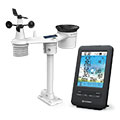
Type of station
BRESSER 4-Tage 4CAST 7003200
these sensors are in use
count
Temperature
1
Air Pressure
1
Precipitation
1
Anemometer
mounting height: 4.92 ft
1
UV
1
Solar radiation
1
Soil temperature
4
Soil moisture
4
Leaf wetness
2
To map
Compare values with adjacent stations
To instrument page of the station
Sponsoring
MEMBERS
11790 Members at this time
8791 stations online
New stations:
Düsseldorf
Brunnihütte Engelbg.
ChoussyBG
Böheimkirchen II
JavichoMeteo
Weather Report
Chatel-Guyon
cloudy / 55.2°F -
Sibenik-Krvavice
overcast sky / 67.3°F -
Current Warnings
no warnings at the moment
Minimum/ Maximum
Temperature
Anderson Mill, TX
97.9°F -
Gilpin County CO
25.5°F -
Wind Speed
Big Timber, MT
29.8 mph - W -
Precipitation
Zeulenroda-Triebes
2.6 in -
Visitors today: 5986
currently 39 visitors on AWEKAS
Display Settings
Language
German
English
Dutch
French
Italian
Spanish
Measurement Units
Metric system
American system