Home
Weather Maps
Tables
Forum
Community
Service
Shop
My AWEKAS
AWEKAS Home
AWEKAS Mobile Home
Data protection
Imprint
Weather overview
Temperature
Air Pressure
Wind
Precipitation
Snow
Webcam
Sun
Dew point
Humidity
Current weather data
Current weather situation
Current weather warnings
Forum overview
News
Help and instructions
Wishes and suggestions
Register new
Memberlist
Member Map
Donations to AWEKAS
Banner and logo
Weather widget
AWEKAS shop
My station panel
Instrument designer
Stationsweb
Change user data
Report your weather
Data import/export
AWEKAS Benutzer:
login
Nearest stations
Information for station Saratoga, CA
Glider, CA
Palo Alto, CA
Saratoga W Valley,CA
Station name
Saratoga, CA
Country
USA
Height above sea level
114 m
Geographical position
122° 1' 23'' West / 37° 16' 28'' North
Data transfer
Weather Display (clientraw.txt)
Last updated
11/29/2025 11:19 pm
AWEKAS Plus
YES
AWEKAS id
1470
Stations blog
edit
no station blog available
Information for station
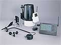
Type of station
Davis Vantage Pro 1 (Plus)
these sensors are in use
count
Temperature
ventilated radiation shield
1
Air Pressure
1
Precipitation
1
Anemometer
mounting height: 32.81 ft
1
UV
1
Solar radiation
1
Link to station website Saratoga, CA
To map
Compare values with adjacent stations
To instrument page of the station
Picture from : 11.29.2025 - 11:23 pm = local time: 1:23pm
Sponsoring
MEMBERS
18422 Members at this time
13133 stations online
New stations:
Altenholz-Klausdorf
Halle Küttener Weg
Böhmzeil
Nelson Rd Milford PA
Morenhoven
Weather Report
Hartberg / Kroisbach
overcast sky / 34.2°F -
Zlin-Stipa
overcast sky -
Current Warnings
no warnings at the moment
Minimum/ Maximum
Temperature
Catamarca cap. (CTC)
96.8°F -
Arsiero Campomolon
2.8°F -
Wind Speed
Brocken DWD
39.4 mph - SW -
Precipitation
Limenas Thassos
3.7 in -
Visitors today: 6790
currently 39 visitors on AWEKAS
Display Settings
Language
German
English
Dutch
French
Italian
Spanish
Measurement Units
Metric system
American system