Home
Weather Maps
Tables
Forum
Community
Service
Shop
My AWEKAS
AWEKAS Home
AWEKAS Mobile Home
Data protection
Imprint
Weather overview
Temperature
Air Pressure
Wind
Precipitation
Snow
Webcam
Sun
Dew point
Humidity
Current weather data
Current weather situation
Current weather warnings
Forum overview
News
Help and instructions
Wishes and suggestions
Register new
Memberlist
Member Map
Donations to AWEKAS
Banner and logo
Weather widget
AWEKAS shop
My station panel
Instrument designer
Stationsweb
Change user data
Report your weather
Data import/export
AWEKAS Benutzer:
login
Nearest stations
Information for station Sommentier
Farvagny
Le Moléson MCH
Marsens MCH
Oron MCH
Payerne MCH
Vaulruz
Vevey MCH
Villargiroud
Villars-Tiercelin
Vuisternens-en-Ogoz
Station name
Sommentier
Country
Switzerland
Height above sea level
906 m
Geographical position
6° 54' 46'' East / 46° 38' 16'' North
Data transfer
Davis Weatherlink (HTX Template)
Last updated
7/23/2025 10:39 pm
AWEKAS Plus
YES
AWEKAS id
10415
Stations blog
edit
no station blog available
Information for station
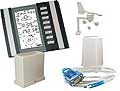
Type of station
WS 2350
these sensors are in use
count
Temperature
1
Air Pressure
1
Precipitation
1
Anemometer
mounting height: 9.84 ft
1
Link to station website Sommentier
To map
Compare values with adjacent stations
To instrument page of the station
Sponsoring
MEMBERS
17812 Members at this time
12560 stations online
New stations:
Grünewaldstraße
Nitzow
Sainte-rose Sofai MF
Wilpoldsried
Ammeloe NRW
Weather Report
Albertville
heavy cloud / 65.5°F -
Big Canoe, GA
partly cloudy / 77.7°F -
Current Warnings
no warnings at the moment
Minimum/ Maximum
Temperature
Hot Springs, AR
102°F -
Balfour
23.4°F -
Wind Speed
Vauclin MF
26.6 mph - SE -
Precipitation
Raesfeld
4.7 in -
Visitors today: 8801
currently 37 visitors on AWEKAS
Display Settings
Language
German
English
Dutch
French
Italian
Spanish
Measurement Units
Metric system
American system