Home
Weather Maps
Tables
Forum
Community
Service
Shop
My AWEKAS
AWEKAS Home
AWEKAS Mobile Home
Data protection
Imprint
Weather overview
Temperature
Air Pressure
Wind
Precipitation
Snow
Webcam
Sun
Dew point
Humidity
Current weather data
Current weather situation
Current weather warnings
Forum overview
News
Help and instructions
Wishes and suggestions
Register new
Memberlist
Member Map
Donations to AWEKAS
Banner and logo
Weather widget
AWEKAS shop
My station panel
Instrument designer
Stationsweb
Change user data
Report your weather
Data import/export
AWEKAS Benutzer:
login
Nearest stations
Information for station Enschede-Stadsveld
Ahaus Mitte-Nord
Ahaus Nord
Ahaus-Ottenstein
B.Bentheim-Gildehaus
De Lutte
De Marke Losser
Enschede-Hogeland
Enschede-Laares
Enschede-Rigtersblek
Enschede-Roombeek
Glanerbrug Oost
Gronau-West
Gronau/W. (Nord)
Haaksbergen-Veldmaat
Haaksbergen-Zuid
Hengelo - Hasselo
Hengelo Centrum
Hengelo(Ov)_ToulonA
Hengelo(Ov)_ToulonB
Overdinkel
Twekkelerveld
Vossenbelt
Vreden-Doemern
Vreden-Lünten
Station name
Enschede-Stadsveld
Country
Netherlands
Height above sea level
35 m
Geographical position
6° 51' 33.47'' East / 52° 12' 43.9'' North
Data transfer
Davis Weatherlink (HTX Template)
Last updated
11.6.2024 23:48
AWEKAS Plus
YES
AWEKAS id
20704
Stations blog
edit
no station blog available
Information for station
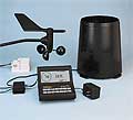
Type of station
Davis Weather MonitorII
these sensors are in use
count
Temperature
1
Air Pressure
1
Precipitation
heated
1
Anemometer
mounting height: 10 m
1
Link to station website Enschede-Stadsveld
To map
Compare values with adjacent stations
To instrument page of the station
Sponsoring
MEMBERS
12008 Members at this time
8817 stations online
New stations:
Notzen
Oude Pekela
Möckern
Niederabsdorf
Metzingen-Neuhausen
Weather Report
Tourrette-Levens
heavy cloud / 15.5°C -
Reichmannsdorf
partly cloudy / 5.2°C -
Current Warnings
no warnings at the moment
Minimum/ Maximum
Temperature
Rancho Ponderosa, AZ
43.9°C -
Ferniehurst
0.4°C -
Wind Speed
Geitanger, Øygarden
54.7km/h - NW -
Precipitation
North Miami
118.4 l/m² -
Visitors today: 31
currently 18 visitors on AWEKAS
Display Settings
Language
German
English
Dutch
French
Italian
Spanish
Measurement Units
Metric system
American system