Facebook
 
 AWEKAS Benutzer: login  
Nearest stations  
Information for station Overdinkel
Ahaus Mitte-Nord
Ahaus Nord
B.Bentheim-Gildehaus
De Lutte
De Marke Losser
Enschede-Hogeland
Enschede-Laares
Enschede-Rigtersblek
Enschede-Roombeek
Enschede-Stadsveld
Glanerbrug Oost
Gronau-West
Gronau/W. (Nord)
Hengelo - Hasselo
Hengelo Centrum
Hengelo(Ov)_ToulonA
Hengelo(Ov)_ToulonB
Nordhorn
Ochtrup
Twekkelerveld
Vossenbelt
Wettringen
Wettringen-Rothenbge
 
  Station name Overdinkel  
Country Netherlands   
Height above sea level 37 m
Geographical position     7° 2' 41'' East / 52° 14' 43'' North
Data transfer WU Fastlink
Last updated 4.6.2024 19:39
AWEKAS Plus YES  
AWEKAS id 15702
 
  Stations blog edit  
 

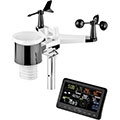
Via fastlink Bresser en WS Vieuw app  verbonden met router ( ws 2900 station ) voor Awekas data levering.

Op  3 meter hoogte geplaatste all in 1 sensorunit.


Information for station
station Type of station  Eurochron EFWS 2900
these sensors are in use count
Temperature 1
Air Pressure 1
Precipitation 1
Anemometer mounting height: 3 m1
UV 1
Solar radiation 1
 
Link to station website Overdinkel
To map
Compare values with adjacent stations
To instrument page of the station
 
 
info
 
Sponsoring
MEMBERS
11948 Members at this time
8887 stations online
New stations:
Breuillet
Badajoz
St. Louis Mo.
Dianteiro
Ellbögen
 
 
Weather Report
Albertville
 cloudy / 25.1°C -
Lambourn
 overcast sky / 14.9°C -
no warnings at the moment
Minimum/ Maximum
Temperature

Seminole, TX
35.9°C -
Ferniehurst
-1.6°C -
Wind Speed
Mosfellsbaer
41.4km/h - NW -
Precipitation
Skrajna BB
110.1 l/m² -
 
Visitors today: 5649
currently 44 visitors on AWEKAS
Display Settings
Language
German English
Dutch French
Italian Spanish
Measurement Units
Metric system
American system