Startpagina
Kaarten
Tabellen
Forum
Community
Service
Mijn AWEKAS
AWEKAS Startpagina
AWEKAS Mobile Startpagina
Privacy Policy
Impressum
Weeroverzicht
Temperatuur
Luchtdruk
Wind
Neerslag
Sneeuwhoogte
Webcam
Zon
Dauwpunt
Luchtvochtigheid
aktuele Weerdata
alle aktuele Weermeldingen
alle Weerwaarschuwingen
Forum overzicht
News
Help en toelichtingen
Wensen und ideeën
nieuw aanmelden
Deelnemerslijst
Deelnemerslijst
AWEKAS ondersteunen
Banneren Logo
Website weerwidget
Mijn stationspagina
Stationsweb
Gebruikersgegevens veranderen
Weer melden
Data- Up- en Download
AWEKAS gebruiker:
login
nabije stations
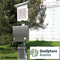
Informatie over het station Bad Goisern Geosp.
Aigen-Strobl
Altaussee
Altaussee - Puchen
Archkogl
Bad Aussee
Bad Aussee-Gallhof
Bad Goisern
Bad Goisern (OÖ)
Bad Goisern, Solbach
Bad Ischl
Bad Ischl - Ahorn
Bad Ischl - Hubkogl
Bad Ischl Geosp.
Bad Ischl Kaltenbach
Dachstein Hunerkogel
Dachstein Schladming
Gosau/Mittertal
Gößl (Stmk.)
Hallstatt
Radau/St.Wolfgang
St.Wolfgang, Graben
St.Wolfgang-Au (SKG)
St.Wolfgang-Weinbach
Stationsnaam
Bad Goisern Geosp.
Land
Oostenrijk
Zeehoogte
538 m
Geografische Positie
13° 38' 41'' Oost / 47° 37' 19'' Noord
Data overdracht
manuell
laatst geactualiseerd
9.10.2025 09:20
AWEKAS Plus
JA
AWEKAS id
43579
Stations Blog
bewerken
geen Stationsblog aanwezig
Informatie over Station
Stationstype
Geosphere Austria TAWES-Messstation
volgende Sensoren zijn aanwezig
Aantal
Temperatuur
1
Luchtdruk
1
Neerslag
1
Windmeter
Montagehoogte: 3 m
1
UV
1
Solarstraling
1
Bodemtemperatuur
4
Bodemvocht
4
Link naar Stationshomepage Bad Goisern Geosp.
naar kaart
in vergelijk met buurtstations
naar Instrumentenpagina van het station
Sponsoring
Deelnemer
18207 geregistreerde stations
13174 Stations online
De nieuwste Stations:
Merklingen (Alb)
Nedre Bäck
Großhau
Plum MF
Brawinkl
Weermeldingen
Bourg-Saint-Bernard
bewolkt / 15.4°C -
Sibenik-Krvavice
onbewolkt / 17°C -
Aktuele Waarschuwingen
momenteel geen waarschuwing aktief
Minimum/ Maximum
Temperatuur
Kanagala
32.8°C -
Jungfraujoch MCH
-3.3°C -
Windsnelheid
Poingam MF
47.5km/h - O -
Neerslag
Hinterbrühl
457.4 l/m² -
Bezoekers vandaag: 3821
op dit moment 49 Bezoekers op AWEKAS
Kaartinstelling
Spraak
Duits
Engels
Nederlands
Frans
Italiaans
Spaans
Meetwaarden
Metrische Systeem
Amerikaanse Systeem