Startpagina
Kaarten
Tabellen
Forum
Community
Service
Mijn AWEKAS
AWEKAS Startpagina
AWEKAS Mobile Startpagina
Privacy Policy
Impressum
Weeroverzicht
Temperatuur
Luchtdruk
Wind
Neerslag
Sneeuwhoogte
Webcam
Zon
Dauwpunt
Luchtvochtigheid
aktuele Weerdata
alle aktuele Weermeldingen
alle Weerwaarschuwingen
Forum overzicht
News
Help en toelichtingen
Wensen und ideeën
nieuw aanmelden
Deelnemerslijst
Deelnemerslijst
AWEKAS ondersteunen
Banneren Logo
Website weerwidget
Mijn stationspagina
Stationsweb
Gebruikersgegevens veranderen
Weer melden
Data- Up- en Download
AWEKAS gebruiker:
login
nabije stations
Informatie over het station Dung (Montbéliard)
Colombier-Fontaine
Appenans
Brebotte, Le Cotais
Couthenans (Nord)
Dorans MF
Evette-Salbert
Fahy MCH
Faymont_sapc MF
Joncherey MF
Luze
Mediere MF
Novillard_sapc MF
Presentevillers
St Dizier-l'evequ MF
Stationsnaam
Dung (Montbéliard)
Land
Frankrijk
Zeehoogte
350 m
Geografische Positie
6° 45' 6.14'' Oost / 47° 30' 12.27'' Noord
Data overdracht
Bresser Fastlink
laatst geactualiseerd
10/16/2025 11:36 pm
AWEKAS Plus
JA
AWEKAS id
25848
Stations Blog
bewerken
geen Stationsblog aanwezig
Informatie over Station
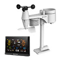
Stationstype
BRESSER WLAN Comfort 7003300
volgende Sensoren zijn aanwezig
Aantal
Temperatuur
1
Neerslag
1
Windmeter
:
1
UV
1
Solarstraling
1
Bodemtemperatuur
4
Bodemvocht
4
Bladvocht
2
naar kaart
in vergelijk met buurtstations
naar Instrumentenpagina van het station
Sponsoring
Deelnemer
18248 geregistreerde stations
13163 Stations online
De nieuwste Stations:
Champtercier
Mataura 1 MF
Sacalaz, Florilor
Precheur-savst MF
Riviera del Sol
Weermeldingen
Hartberg / Kroisbach
bewolkt / 51.8°F -
Big Canoe, GA
wis. bewolkt / 71.1°F -
Aktuele Waarschuwingen
Brakbos eiland
extreme hitte >35°C
Minimum/ Maximum
Temperatuur
Mission TX
91.6°F -
Aiguille Du Midi MF
21.7°F -
Windsnelheid
Montreuil-sur-Epte
36.7 mph - NW -
Neerslag
Burgtreswitz
12 in -
Bezoekers vandaag: 5765
op dit moment 17 Bezoekers op AWEKAS
Kaartinstelling
Spraak
Duits
Engels
Nederlands
Frans
Italiaans
Spaans
Meetwaarden
Metrische Systeem
Amerikaanse Systeem