
|
Country
Netherlands
 Height above sea level
51 m
6° 59' 15'' East / 52° 18' 58'' North
Data transfer
Meteobridge Direct Link
Last updated
26.6.2026 10:40
AWEKAS Plus
YES
AWEKAS id
9058
|
|---|

|
||||
|---|---|---|---|---|
|
Information for station
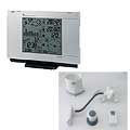
Type of station
Cresta WXR815
 these sensors are in use count
Temperature 1 Air Pressure 1 Precipitation 1 Anemometer mounting height: 6 m 1 UV 1 Solar radiation 1 Soil temperature 4 Soil moisture 4 Leaf wetness 2 Extra humidity sensor 4 Air quality sensor 1
|
|---|