
|
Country
France
 Height above sea level
164 m
2° 7' 18.28'' East / 48° 41' 20.25'' North
Data transfer
WSWIN Direct Link
Last updated
25.7.2026 13:20
AWEKAS Plus
YES
AWEKAS id
27582
|
|---|

|
||||
|---|---|---|---|---|
|
Information for station
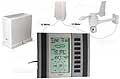
Type of station
WS 2300
 these sensors are in use count
Temperature ventilated radiation shield 1 Air Pressure 1 Precipitation 1 Anemometer mounting height: 10 m 1 Solar radiation 1
|
|---|