Facebook
 
 AWEKAS Benutzer: login  
Nearest stations  
Information for station Champhol La Mihoue
Amilly-Ouerray
Challet
Chartres MF
Houx MF
Maingournois
Minières
Sours_sapc MF
St-Symphorien-le-Châ
Thimert MF
 
  Station name Champhol La Mihoue  
Country France   
Height above sea level 154 m
Geographical position     1° 29' 58.88'' East / 48° 27' 53.57'' North
Data transfer Bresser Fastlink
Last updated 9/22/2025 6:36 am
AWEKAS Plus YES  
AWEKAS id 24374
 
  Stations blog edit  
 
no station blog available
 
 
Information for station
station Type of station  BRESSER WLAN Comfort 7003300
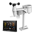
these sensors are in use count
Temperature 1
Air Pressure 1
Precipitation 1
Anemometer mounting height: 6.56 ft1
UV 1
Solar radiation 1


To map
Compare values with adjacent stations
To instrument page of the station
 
 
info
 
Sponsoring
MEMBERS
18149 Members at this time
13116 stations online
New stations:
Hepstedt
Tüngental 2
Tüngental
Macisvenda
Vesdun
 
 
Weather Report
Lochaber
 overcast sky / 37.6°F -
Viviers
 heavy cloud / 58.5°F -
Bamlach
 constant rain
Minimum/ Maximum
Temperature

Hartberg / Kroisbach
91.8°F -
Pic Du Midi - Obs MF
23°F -
Wind Speed
Patscherkofel
41.8 mph - S -
Precipitation
Plourhan St-Barnabé
2.9 in -
 
Visitors today: 1907
currently 46 visitors on AWEKAS
Display Settings
Language
German English
Dutch French
Italian Spanish
Measurement Units
Metric system
American system