
|
Country
Germany
 Height above sea level
453 m
13° 33' 54.77'' East / 48° 36' 48.88'' North
Data transfer
Bresser Fastlink
Last updated
16.12.2022 12:37
AWEKAS Plus
YES
AWEKAS id
20817
|
|---|

|
||||
|---|---|---|---|---|
|
Information for station
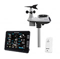
Type of station
BRESSER Profi W-LAN Wetter Center 6in1
 these sensors are in use count
Temperature ventilated radiation shield 1 Air Pressure 1 Precipitation 1 Anemometer mounting height: 8 m 1 UV 1 Solar radiation 1 Soil temperature 1 Extra humidity sensor 1 Air quality sensor 1
|
|---|