Facebook
 
 AWEKAS Benutzer: login  
Nearest stations  
Information for station Biengen (Süd)
B.Krozgn-Schmidhofen
Bad Krozingen Nord
Bad Krozingen-Tunsel
Badenweiler
Biengen
Breisach
Buggingen-Betberg
Buggingen-Seefelden
Ehrenkirchen
Eschbach
Freibg.-Waltershofen
Freiburg Tiengen II
Freiburg-Rieselfeld
Freiburg-Tiengen
Hausen a. d. Möhlin
Hirtzfelden
Hochblauen
Merdingen
Müllheim, Zielberg
Nambsheim
Neuenburg (Rhein)
Pfaffenweiler
Schlatt (Breisgau)
Staufen i. Breisgau
Staufen im Breisgau
Untermünstertal
Wittnau
 
  Station name Biengen (Süd)  
Country Germany   
Height above sea level 221 m
Geographical position     7° 41' 22.22'' East / 47° 56' 10.26'' North
Data transfer Froggit Fastlink
Last updated 3.5.2025 09:22
AWEKAS Plus YES  
AWEKAS id 20508
 
  Stations blog edit  
 
no station blog available
 
 
Information for station
station Type of station  Froggit WH3000
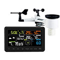
these sensors are in use count
Temperature 1
Air Pressure 1
Precipitation 1
Anemometer mounting height: 4 m1


To map
Compare values with adjacent stations
To instrument page of the station
 
 
info
 
Sponsoring
MEMBERS
14339 Members at this time
9900 stations online
New stations:
Flugplatz Köthen
Würzburg
Emmen
Kornbakken
Stölpchen
 
 
Weather Report
Cuers
 cloudy / 17.8°C -
Viviers
 sunny sky / 15°C -
no warnings at the moment
Minimum/ Maximum
Temperature

Kanagala
36.7°C -
Oppdal
0.3°C -
Wind Speed
Sommand Roche Pallud
38.8km/h - SE -
Precipitation
Vega Baja
113.5 l/m² -
 
Visitors today: 1917
currently 62 visitors on AWEKAS
Display Settings
Language
German English
Dutch French
Italian Spanish
Measurement Units
Metric system
American system