Home
Weather Maps
Tables
Forum
Community
Service
Shop
My AWEKAS
AWEKAS Home
AWEKAS Mobile Home
Data protection
Imprint
Weather overview
Temperature
Air Pressure
Wind
Precipitation
Snow
Webcam
Sun
Dew point
Humidity
Current weather data
Current weather situation
Current weather warnings
Forum overview
News
Help and instructions
Wishes and suggestions
Register new
Memberlist
Member Map
Donations to AWEKAS
Banner and logo
Weather widget
AWEKAS shop
My station panel
Instrument designer
Stationsweb
Change user data
Report your weather
Data import/export
AWEKAS Benutzer:
login
Nearest stations
Information for station Burglengenfeld 1
Burglengenfeld
Burglengenfeld 1+
Lappersdorf-Kareth
Maxhütte-Haidhof
Maxhütte-Haidhof 2
Münchsried
Polzhausen
Regenstauf (Süd)
Regenstauf-Diesenb.
Schwandorf,Klardorf
Weißenkirchen
Wenzenb.-Fussenberg
Station name
Burglengenfeld 1
Country
Germany
Height above sea level
409 m
Geographical position
12° 3' 42.22'' East / 49° 12' 15.03'' North
Data transfer
Froggit Fastlink
Last updated
6/3/2024 3:52 pm
AWEKAS Plus
YES
AWEKAS id
20305
Stations blog
edit
no station blog available
Information for station
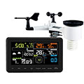
Type of station
Froggit WH3000
these sensors are in use
count
Temperature
ventilated radiation shield
1
Air Pressure
1
Precipitation
1
Anemometer
mounting height: 5.91 ft
1
UV
1
Solar radiation
1
To map
Compare values with adjacent stations
To instrument page of the station
Sponsoring
MEMBERS
11940 Members at this time
8846 stations online
New stations:
Ellbögen
(A)Ouled Boutabet
Hausen
Clovis, NM
Lomske-Radibor
Weather Report
Reichmannsdorf
cloudy / 59.4°F -
Chatel-Guyon
cloudy / 59.5°F -
Current Warnings
no warnings at the moment
Minimum/ Maximum
Temperature
Ag.Dimitrios Viotias
99.3°F -
Bezina - SL.Konjice
32.2°F -
Wind Speed
Tarifa
28 mph - E -
Precipitation
Raubling-Pfraundorf
4.3 in -
Visitors today: 5057
currently 62 visitors on AWEKAS
Display Settings
Language
German
English
Dutch
French
Italian
Spanish
Measurement Units
Metric system
American system