Facebook
 
 AWEKAS gebruiker: login  
nabije stations  
Informatie over het station Drejø Svendborg
 
  Stationsnaam Drejø Svendborg  
Land Denemarken   
Zeehoogte 7 m
Geografische Positie    10° 24' 27.53'' Oost / 54° 58' 23.04'' Noord
Data overdracht Bresser Fastlink
laatst geactualiseerd 17.6.2025 21:50
AWEKAS Plus JA  
AWEKAS id 22880
 
  Stations Blog bewerken  
 

Now fixed: The station sometimes makes horizontal lines(same values) 5 to 6 hours every Day. Bresser explain it with a network error. Maybe they are right, but ther is no problem with internet or streaming radio and tv? I have mobile network LTE 4G with a fine connection and outdoor antenna. I tried to install it another place with fiber network, and there was no problem. Where I live I only have LTE network, can anybody help? Tried different routers and sim, but no solution! Solution found: A no public firmware from Bresser, send by mail!


Informatie over Station
station Stationstype  BRESSER MeteoChamp HD 7003510
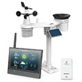
volgende Sensoren zijn aanwezig Aantal
Temperatuur aktief geventileerd1
Luchtdruk 1
Neerslag 1
Windmeter Montagehoogte: 5 m1
UV 1
Solarstraling 1
Bodemtemperatuur 1
 
Link naar Stationshomepage Drejø Svendborg
 
naar kaart
in vergelijk met buurtstations
naar Instrumentenpagina van het station
 
 
info
 
Sponsoring
Deelnemer
14861 geregistreerde stations
10333 Stations online
De nieuwste Stations:
Friedrichsdorf
Langendorf
Krankenhagen
Senftenberg
Köpenick
 
 
Weermeldingen
Chatel-Guyon
 bewolkt / 21.7°C -
Big Canoe, GA
 onbewolkt / 26°C -
momenteel geen waarschuwing aktief
Minimum/ Maximum
Temperatuur

Phoenix-Foothills,AZ
42.4°C -
Balfour
-4.8°C -
Windsnelheid
Säby (Tjörn)
42.8km/h - W -
Neerslag
Ca' Domenichino
117.6 l/m² -
 
Bezoekers vandaag: 6415
op dit moment 34 Bezoekers op AWEKAS
Kaartinstelling
Spraak
Duits Engels
Nederlands Frans
Italiaans Spaans
Meetwaarden
Metrische Systeem
Amerikaanse Systeem